Mounted Print > North America > United States of America > New York > New York > Maps
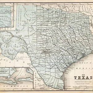
Mounted Print : Map of Texas 1855


![]()
Mounted Prints from Fine Art Storehouse
Map of Texas 1855
System of Geography for the use of schools by Sidney E. Morse - Published by Harper & Brothers - New York 1855
Unleash your creativity and transform your space into a visual masterpiece!
THEPALMER
Media ID 13668807
© Roberto A Sanchez
Backgrounds Frame Grunge Grunge Image Technique Gulf Coast States Map03 North America Paper Patina Stained Texas Textured Effect West Direction Wild West Obsolete Retro Styled
10"x8" Mount with 8"x6" Print
Introducing the captivating Map of Texas from 1855, part of our exclusive Media Storehouse Mounted Photos collection. This antique map, titled "Map of Texas from the System of Geography for the use of schools," was published by Harper & Brothers in New York. The map, created by renowned cartographer S.E. Morse and beautifully illustrated by THEPALMER, offers a fascinating glimpse into the history of Texas during this period. Each mounted photo is meticulously printed on premium photo paper and carefully mounted on a sturdy backing, ensuring a high-quality and long-lasting display. Bring a touch of history and intrigue to your home or office with this exquisite piece from the past.
Printed on 8"x6" paper and suitable for use in a 10"x8" frame (frame not included). Prints are mounted with card both front and back. Featuring a custom cut aperture to match chosen image. Professional 234gsm Fujifilm Crystal Archive DP II paper.
Photo prints supplied in custom cut card mount ready for framing
Estimated Image Size (if not cropped) is 15.2cm x 18cm (6" x 7.1")
Estimated Product Size is 20.3cm x 25.4cm (8" x 10")
These are individually made so all sizes are approximate
Artwork printed orientated as per the preview above, with portrait (vertical) orientation to match the source image.
FEATURES IN THESE COLLECTIONS
> Fine Art Storehouse
> The Magical World of Illustration
> Palmer Illustrated Collection
> Fine Art Storehouse
> Map
> Historical Maps
> Fine Art Storehouse
> Map
> USA Maps
> Maps and Charts
> Related Images
> North America
> Related Images
> North America
> United States of America
> Maps
> North America
> United States of America
> New York
> New York
> Maps
> North America
> United States of America
> New York
> Related Images
> North America
> United States of America
> Texas
> Related Images
EDITORS COMMENTS
This vintage print of the "Map of Texas 1855" takes us back in time to the era of the Wild West. Published by Harper & Brothers in New York, this engraved image showcases a beautifully detailed cartography that was once used for educational purposes in schools. The retro-styled map, with its stained and textured effect, exudes an air of nostalgia and patina. The frame surrounding the map adds to its old-world charm, while the grunge image technique gives it a weathered appearance. As we gaze upon this piece, we are transported to a bygone era when Texas was still developing as part of North America's expanding frontier. The map itself provides insight into the physical geography of Texas during that period. It highlights key landmarks such as the Gulf Coast states and offers a glimpse into how early settlers navigated through this vast territory. Printed on aged paper, this engraving captures not only historical accuracy but also evokes a sense of adventure and exploration. Its vertical orientation allows us to appreciate every intricate detail meticulously etched onto its surface. "The Map of Texas 1855" is more than just an obsolete artifact; it is an artistic representation that tells stories from our past. With its grunge aesthetic and captivating illustration style, it serves as both a decorative piece for any space and a window into history's rich tapestry
MADE IN THE UK
Safe Shipping with 30 Day Money Back Guarantee
FREE PERSONALISATION*
We are proud to offer a range of customisation features including Personalised Captions, Color Filters and Picture Zoom Tools
SECURE PAYMENTS
We happily accept a wide range of payment options so you can pay for the things you need in the way that is most convenient for you
* Options may vary by product and licensing agreement. Zoomed Pictures can be adjusted in the Basket.