Mounted Print > Asia > China > Maps
Mounted Print : Asia map 1875


![]()
Mounted Prints from Fine Art Storehouse
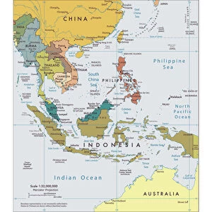
Asia map 1875
The Independent Course Comprehensive Geography by James Monteith, A.S. Barnes & Co, New York & Chicago 1875
Unleash your creativity and transform your space into a visual masterpiece!
THEPALMER
Media ID 13612237
© This content is subject to copyright
China East Asia Globe Navigational Equipment India Indochina Japan Paper Vietnam China East Asia Drawing Art Product
10"x8" Mount with 8"x6" Print
Step back in time with our exquisite mounted photo from Media Storehouse's Fine Art Storehouse collection. This captivating piece features an intricately detailed Asia map from 1875, taken from The Independent Course in Comprehensive Geography by James Monteith, published by A.S. Barnes & Co, New York & Chicago. The vintage map, titled "THEPALMER'S New Map of Asia," showcases the geographical layout of Asia during this era, making it an essential addition to any history or geography enthusiast's collection. The high-quality mounting ensures a stunning presentation, preserving the historical accuracy and intricacy of the map for generations to come.
Printed on 8"x6" paper and suitable for use in a 10"x8" frame (frame not included). Prints are mounted with card both front and back. Featuring a custom cut aperture to match chosen image. Professional 234gsm Fujifilm Crystal Archive DP II paper.
Photo prints supplied in custom cut card mount ready for framing
Estimated Image Size (if not cropped) is 19.6cm x 15.2cm (7.7" x 6")
Estimated Product Size is 25.4cm x 20.3cm (10" x 8")
These are individually made so all sizes are approximate
Artwork printed orientated as per the preview above, with landscape (horizontal) orientation to match the source image.
FEATURES IN THESE COLLECTIONS
> Fine Art Storehouse
> The Magical World of Illustration
> Palmer Illustrated Collection
> Fine Art Storehouse
> Map
> Historical Maps
> Asia
> India
> Related Images
> Asia
> Japan
> Related Images
> Asia
> Related Images
> Asia
> Vietnam
> Related Images
> Maps and Charts
> India
EDITORS COMMENTS
This print takes us back in time to the year 1875, when James Monteith's "The Independent Course Comprehensive Geography" was published. The map displayed is an exquisite representation of Asia during that era. With its intricate details and delicate engravings, it offers a glimpse into the geographical landscape of countries such as China, India, Indochina, Japan, and Vietnam. As we observe this historical artifact closely, we are transported to a world where cartography was meticulously crafted by hand. The fine lines etched onto paper reveal the dedication and skill required to create such a masterpiece. This antique map serves as a testament to human curiosity and exploration. The image showcases not only the physical geography of Asia but also highlights how nations were interconnected through trade routes and cultural exchange. It reminds us of the vastness and diversity present within this continent. Displayed horizontally with precision framing, this print captures every minute detail of the original engraving. Its vintage charm adds depth to any space it graces – be it an office or home setting. "The Independent Course Comprehensive Geography" by James Monteith continues to inspire awe even after all these years. As we admire this artful creation brought forth by THEPALMER from Fine Art Storehouse, we can't help but appreciate both its aesthetic appeal and historical significance.
MADE IN THE UK
Safe Shipping with 30 Day Money Back Guarantee
FREE PERSONALISATION*
We are proud to offer a range of customisation features including Personalised Captions, Color Filters and Picture Zoom Tools
SECURE PAYMENTS
We happily accept a wide range of payment options so you can pay for the things you need in the way that is most convenient for you
* Options may vary by product and licensing agreement. Zoomed Pictures can be adjusted in the Basket.