Mounted Print > Europe > Albania > Maps
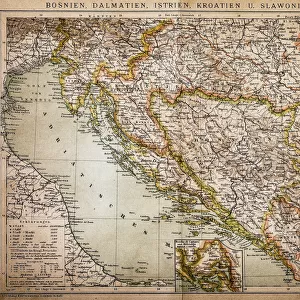
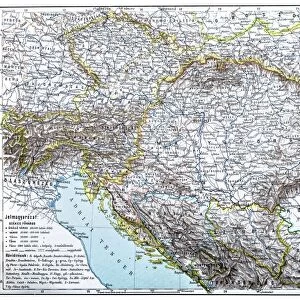
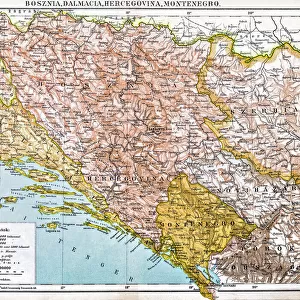
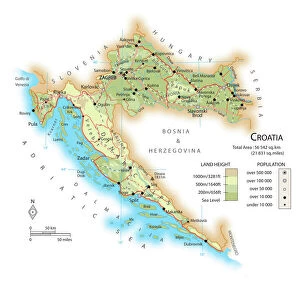
Mounted Print : Belovar-koros, Croatio map from 1893


![]()
Mounted Prints from Fine Art Storehouse
Belovar-koros, Croatio map from 1893
Antique illustration of a Belovar-koros, Croatio map from 1893
Unleash your creativity and transform your space into a visual masterpiece!
Nastasic
Media ID 13589853
© This content is subject to copyright
Adriatic Sea Albania Austria Austrian Culture Balkans Bohemia Bosnia And Hercegovina Cartographer Contour Drawing Country Geographic Area Croatia Dalmatia Region Croatia Galicia Hapsburg Dynasty Hungarian Culture Hungary Istria Mediterranean Sea Montenegro Moravia Photography Themes Romania Royalty Serbia Slovenia Topography Transylvania
10"x8" Mount with 8"x6" Print
Step back in time with our exquisite antique map print from the Media Storehouse Fine Art collection. This beautifully preserved illustration of Belovar-Koros, Croatia, dates back to 1893 and was created by the renowned cartographer Nastasic. The intricate details and vibrant colors bring the history of this region to life, making it a stunning addition to any home or office. Our high-quality mounted photo is printed on premium paper and comes ready to hang, ensuring a long-lasting display of this precious piece of history.
Printed on 8"x6" paper and suitable for use in a 10"x8" frame (frame not included). Prints are mounted with card both front and back. Featuring a custom cut aperture to match chosen image. Professional 234gsm Fujifilm Crystal Archive DP II paper.
Photo prints supplied in custom cut card mount ready for framing
Estimated Image Size (if not cropped) is 19.2cm x 15.2cm (7.6" x 6")
Estimated Product Size is 25.4cm x 20.3cm (10" x 8")
These are individually made so all sizes are approximate
Artwork printed orientated as per the preview above, with landscape (horizontal) orientation to match the source image.
FEATURES IN THESE COLLECTIONS
> Fine Art Storehouse
> The Magical World of Illustration
> Nastasic Images & Illustrations
> Fine Art Storehouse
> Map
> Historical Maps
> Fine Art Storehouse
> Map
> Italian Maps
> Europe
> Albania
> Related Images
> Europe
> Austria
> Related Images
> Europe
> Bosnia and Herzegovina
> Maps
> Europe
> Croatia
> Related Images
EDITORS COMMENTS
This print showcases an exquisite antique illustration of the Belovar-koros region in Croatia, dating back to 1893. With its intricate details and historical significance, this map takes us on a journey through time, offering a glimpse into the past of the Balkans. Spanning across Hungary, Romania, Austria, Germany, Italy, Albania, Serbia, Montenegro and more, it highlights the diverse cultural tapestry that once thrived in this part of Europe. The expertly engraved image captures the essence of cartography as practiced during that era. The contour drawing beautifully depicts the topography of the land while showcasing various geographic features such as rivers and mountain ranges. This lithograph is a testament to both artistic skill and scientific accuracy. As we delve into this piece's rich history further still, we discover its connection to significant dynasties like Hapsburg and their influence on Austrian culture. The Adriatic Sea glistens prominently alongside other notable regions like Dalmatia and Istria. Nastasic's masterful photography preserves this remarkable work for future generations to appreciate. It serves as a reminder not only of our collective heritage but also of how far cartography has evolved over time.
MADE IN THE UK
Safe Shipping with 30 Day Money Back Guarantee
FREE PERSONALISATION*
We are proud to offer a range of customisation features including Personalised Captions, Color Filters and Picture Zoom Tools
SECURE PAYMENTS
We happily accept a wide range of payment options so you can pay for the things you need in the way that is most convenient for you
* Options may vary by product and licensing agreement. Zoomed Pictures can be adjusted in the Basket.