Mounted Print > Arts > Modern art pieces
Mounted Print : Plan of the Battle of Hlobane, Anglo Zulu war


![]()
Mounted Prints from Fine Art Storehouse
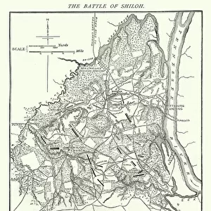
Plan of the Battle of Hlobane, Anglo Zulu war
Vintage illustration of Plan of the Battle of Hlobane, (28 March 1879) took place at Hlobane, near the modern town of Vryheid in KwaZulu-Natal, South Africa during the Anglo-Zulu War
Unleash your creativity and transform your space into a visual masterpiece!
duncan1890
Media ID 32086703
© of Duncan P Walker
Anglo Zulu War Supplies Victorian
10"x8" Mount with 8"x6" Print
Step back in time with our vintage illustration of the Plan of the Battle of Hlobane from the Media Storehouse range of Mounted Photos. This captivating piece, sourced from Fine Art Storehouse and created by duncan1890, transports you to the Anglo-Zulu War of 1879. The intricate detail of this plan showcases the strategic layout of the battle that took place near Vryheid in KwaZulu-Natal, South Africa. Each mounted photo is carefully printed on high-quality archival paper and elegantly mounted on a sturdy board, ensuring your historical treasure remains preserved for generations to come. Add this unique and educational piece to your collection and bring a piece of history into your home or office.
Printed on 8"x6" paper and suitable for use in a 10"x8" frame (frame not included). Prints are mounted with card both front and back. Featuring a custom cut aperture to match chosen image. Professional 234gsm Fujifilm Crystal Archive DP II paper.
Photo prints supplied in custom cut card mount ready for framing
Estimated Image Size (if not cropped) is 19cm x 15.2cm (7.5" x 6")
Estimated Product Size is 25.4cm x 20.3cm (10" x 8")
These are individually made so all sizes are approximate
Artwork printed orientated as per the preview above, with landscape (horizontal) orientation to match the source image.
FEATURES IN THESE COLLECTIONS
> Fine Art Storehouse
> History
> Battles & Wars
> Historcal Battle Maps and Plans
> Africa
> South Africa
> Related Images
> Historic
> Battles
> Related Images
EDITORS COMMENTS
This vintage illustration captures the intricate details of the "Plan of the Battle of Hlobane" during the Anglo-Zulu War. The battle, which occurred on 28th March 1879 near Vryheid in KwaZulu-Natal, South Africa, was a significant event in this historic conflict. The print showcases a meticulously drawn map that outlines the strategic movements and positions of both British and Zulu forces during this intense encounter. It offers a glimpse into the tactical planning involved in such battles, highlighting key areas and supply routes crucial for both sides. The Victorian era aesthetic adds an air of authenticity to this historical artifact, transporting viewers back to a time when wars were fought with maps and compasses rather than modern technology. It serves as a reminder of how warfare has evolved over time. Duncan1890's attention to detail is evident in every line and symbol on this print, making it not only visually captivating but also informative for those interested in military history or studying past conflicts. Whether displayed as part of a collection or used as an educational resource, this print brings to life an important chapter from the Anglo-Zulu War. Its historical significance combined with its artistic appeal makes it an intriguing piece that will surely spark conversation and curiosity among admirers.
MADE IN THE UK
Safe Shipping with 30 Day Money Back Guarantee
FREE PERSONALISATION*
We are proud to offer a range of customisation features including Personalised Captions, Color Filters and Picture Zoom Tools
SECURE PAYMENTS
We happily accept a wide range of payment options so you can pay for the things you need in the way that is most convenient for you
* Options may vary by product and licensing agreement. Zoomed Pictures can be adjusted in the Basket.