Mounted Print > Arts > Artists > C > Juan de la Cosa
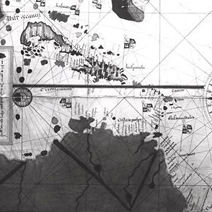
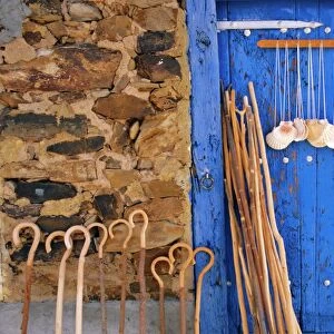
Mounted Print : Map of countries first discovered by Christopher Columbus (1451-1506) 1500 (gouache
 1500 (gouache")
 1500 (gouache")


![]()
Mounted Prints from Fine Art Finder
Map of countries first discovered by Christopher Columbus (1451-1506) 1500 (gouache
XIR226789 Map of countries first discovered by Christopher Columbus (1451-1506) 1500 (gouache and pen and ink on paper) (b/w photo) by Cosa, Juan de la (1460-1510); Museo Naval, Madrid, Spain; Spanish, out of copyright
Media ID 12729563
© www.bridgemanimages.com
Antilles Bahamas Caribbean Carte Christophe Colomb Cuba Iles Islands
10"x8" Mount with 8"x6" Print
Discover the fascinating history of exploration with our exquisite Mounted Photos from Media Storehouse. This captivating piece features a rare map depicting the lands first discovered by the legendary explorer, Christopher Columbus. Dated back to 1500, this stunning gouache and pen and ink on paper map by Juan de la Cosa showcases the new world as it was once charted. Bring history to life in your home or office with this beautifully mounted and preserved image. Order now and travel back in time with every glance.
Printed on 8"x6" paper and suitable for use in a 10"x8" frame (frame not included). Prints are mounted with card both front and back. Featuring a custom cut aperture to match chosen image. Professional 234gsm Fujifilm Crystal Archive DP II paper.
Photo prints supplied in custom cut card mount ready for framing
Estimated Image Size (if not cropped) is 20.3cm x 15.1cm (8" x 5.9")
Estimated Product Size is 25.4cm x 20.3cm (10" x 8")
These are individually made so all sizes are approximate
Artwork printed orientated as per the preview above, with landscape (horizontal) orientation to match the source image.
FEATURES IN THESE COLLECTIONS
> Fine Art Finder
> Artists
> Juan de la Cosa
> Fine Art Finder
> Maps (celestial & Terrestrial)
> Arts
> Artists
> C
> Juan de la Cosa
> Europe
> Spain
> Related Images
> Maps and Charts
> Related Images
> Maps and Charts
> Spain
> North America
> The Bahamas
> Maps
> North America
> The Bahamas
> Related Images
EDITORS COMMENTS
This print showcases a remarkable piece of history - the "Map of countries first discovered by Christopher Columbus (1451-1506) 1500". Created by Juan de la Cosa, a renowned Spanish cartographer, this gouache and pen and ink masterpiece is housed in the Museo Naval in Madrid, Spain. The map takes us back to the era when exploration was at its peak. It vividly illustrates the territories that were first encountered by Christopher Columbus during his groundbreaking voyages. From Cuba to the Caribbean, from the Bahamas to the Americas, this meticulously detailed map offers a glimpse into an age of discovery. With its black and white composition, this photograph captures every intricate line and stroke made by de la Cosa's skilled hand. The delicate balance between precision and artistry is evident as we admire each island meticulously rendered on paper. As we delve into this image, it becomes clear that it represents more than just geographical information; it symbolizes human curiosity and ambition. It reminds us of Columbus' daring spirit as he embarked on uncharted waters in search of new lands. This print serves as a testament to our collective past while also igniting our imagination for what lies beyond. It invites us to reflect on how these early explorations shaped our world today. Let us appreciate not only the beauty captured within this artwork but also ponder upon the courage required to venture into unknown territories centuries ago.
MADE IN THE UK
Safe Shipping with 30 Day Money Back Guarantee
FREE PERSONALISATION*
We are proud to offer a range of customisation features including Personalised Captions, Color Filters and Picture Zoom Tools
SECURE PAYMENTS
We happily accept a wide range of payment options so you can pay for the things you need in the way that is most convenient for you
* Options may vary by product and licensing agreement. Zoomed Pictures can be adjusted in the Basket.