Mounted Print > South America > Brazil > Maps
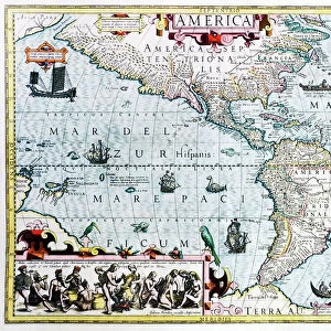
Mounted Print : Map Of Northern Brazil, Circa. 1760. From "Atlas De Toutes Les Parties Connues Du Globe Terrestre "By Cartographer Rigobert Bonne. Published Geneva Circa. 1760


![]()
Mounted Prints from Design Pics
Map Of Northern Brazil, Circa. 1760. From "Atlas De Toutes Les Parties Connues Du Globe Terrestre "By Cartographer Rigobert Bonne. Published Geneva Circa. 1760
Map Of Northern Brazil, Circa.1760. From " Atlas De Toutes Les Parties Connues Du Globe Terrestre " By Cartographer Rigobert Bonne. Published Geneva Circa. 1760
Design Pics offers Distinctively Different Imagery representing over 1,500 contributors
Media ID 18186408
© Ken Welsh / Design Pics
Brazil Cartography Geography Mapmaking Northern Plate
10"x8" Mount with 8"x6" Print
Step back in time with our exquisite Mounted Photo featuring a rare and captivating map of Northern Brazil, circa 1760. Hailing from the "Atlas De Toutes Les Parties Connues Du Globe Terrestre" by renowned cartographer Rigobert Bonne, this antique map was published in Geneva around 1760. With intricate detail and rich history, this vintage map of Northern Brazil is a stunning addition to any decor. Our high-quality mounted photo preserves the authenticity and beauty of this historical cartographic masterpiece. Travel back in time and adorn your walls with a piece of history from Design Pics' Media Storehouse collection.
Printed on 8"x6" paper and suitable for use in a 10"x8" frame (frame not included). Prints are mounted with card both front and back. Featuring a custom cut aperture to match chosen image. Professional 234gsm Fujifilm Crystal Archive DP II paper.
Photo prints supplied in custom cut card mount ready for framing
Estimated Image Size (if not cropped) is 20.3cm x 13.8cm (8" x 5.4")
Estimated Product Size is 25.4cm x 20.3cm (10" x 8")
These are individually made so all sizes are approximate
Artwork printed orientated as per the preview above, with landscape (horizontal) orientation to match the source image.
FEATURES IN THESE COLLECTIONS
> South America
> Brazil
> Maps
> South America
> Brazil
> Related Images
EDITORS COMMENTS
This print showcases a remarkable piece of cartographic history - the Map of Northern Brazil, Circa. 1760. From "Atlas De Toutes Les Parties Connues Du Globe Terrestre" by renowned cartographer Rigobert Bonne, this exquisite engraving was published in Geneva around 1760. The map itself is a true testament to the artistry and precision of early mapmaking. Its vibrant colors and intricate details transport us back in time, offering a glimpse into the geographical knowledge and exploration of that era. As we delve into this horizontal illustration, we are immersed in the vastness and diversity of Northern Brazil's landscape. From lush rainforests to winding rivers, from sprawling coastlines to majestic mountains, every contour is meticulously depicted with utmost accuracy. Beyond its aesthetic appeal, this historical artifact serves as an invaluable resource for understanding the geography and topography of Northern Brazil during the 18th century. It provides valuable insights into how our perception of landforms has evolved over time. Ken Welsh's expertly captured photograph allows us to appreciate not only the beauty but also the significance of this antique map plate. It reminds us that maps are not just tools for navigation; they are windows into our past and gateways to discovering new horizons.
MADE IN THE UK
Safe Shipping with 30 Day Money Back Guarantee
FREE PERSONALISATION*
We are proud to offer a range of customisation features including Personalised Captions, Color Filters and Picture Zoom Tools
SECURE PAYMENTS
We happily accept a wide range of payment options so you can pay for the things you need in the way that is most convenient for you
* Options may vary by product and licensing agreement. Zoomed Pictures can be adjusted in the Basket.