Metal Print > Maps and Charts > Abraham Ortelius
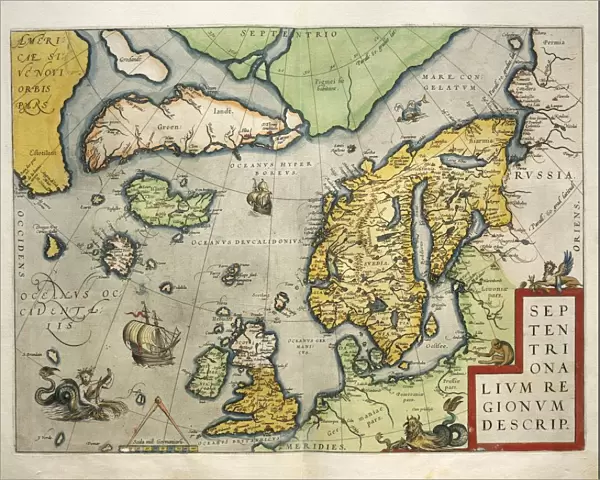
Metal Print : Map of Northern Europe, from Theatrum Orbis Terrarum by Abraham Ortelius, 1528-1598, 1570


![]()
Metal Prints from Universal Images Group (UIG)
Map of Northern Europe, from Theatrum Orbis Terrarum by Abraham Ortelius, 1528-1598, 1570
Cartography, 16th century. Map of Northern Europe, from Theatrum Orbis Terrarum by Abraham Ortelius (1528-1598), Antwerp, 1570
Universal Images Group (UIG) manages distribution for many leading specialist agencies worldwide
Media ID 9505609
© DEA / A. DAGLI ORTI
1570 16th Century Abraham Ortelius Aerial View Coastline Denmark Finland Greenland Guidance Iceland Island Latin Script Nautical Vessel Navigational Equipment Norway Peninsula River Sailing Ship Scandinavia Ship Sweden Text Theatrum Orbis Terrarum Non Urban Scene
20"x16" (51x41cm) Metal Print
Step back in time with our stunning Metal Print of the iconic Map of Northern Europe from Theatrum Orbis Terrarum by Abraham Ortelius. Dated back to 1570, this exquisite 16th-century map showcases the intricate details of Northern Europe during the Renaissance era. The Metal Print's vibrant colors and sharp contrasts bring out the intricate cartography, making it a captivating addition to any room. With its sleek, modern metal finish, this map is not only a beautiful work of art but also a testament to the rich history of cartography. Bring history to life with this unique and eye-catching piece from the Media Storehouse range of Metal Prints.
Your image is printed photographically and bonded to a 3.5mm thick, Dibond board (black polyethylene sandwiched between two sheets of white coated aluminium). The panel is then sealed with a gloss protective covering. Supplied complete with a wall mount which holds the print 10mm from the wall.
Made with durable metal and luxurious printing techniques, metal prints bring images to life and add a modern touch to any space
Estimated Product Size is 50.8cm x 40.6cm (20" x 16")
These are individually made so all sizes are approximate
Artwork printed orientated as per the preview above, with landscape (horizontal) or portrait (vertical) orientation to match the source image.
FEATURES IN THESE COLLECTIONS
> Maps and Charts
> Abraham Ortelius
> Universal Images Group (UIG)
> Art
> Painting, Sculpture & Prints
> Cartography
EDITORS COMMENTS
This print showcases a remarkable piece of cartography from the 16th century. The image features a Map of Northern Europe, meticulously crafted by Abraham Ortelius (1528-1598) and published in Antwerp in 1570 as part of his renowned work, Theatrum Orbis Terrarum. The map provides an intricate depiction of the topography and physical geography of the region, encompassing countries such as Finland, Sweden, Denmark, Norway, Iceland, and even Greenland. Its detailed illustrations highlight rivers snaking through lush landscapes while coastlines gracefully meet with vast bodies of water. A sailing ship gracefully glides across the sea on its journey through these northern European waters. This aerial view offers a glimpse into how navigational equipment was utilized during this era for safe passage along treacherous coastlines. The Latin script accompanying the map serves as both guidance and historical documentation. It transports us back to a time when exploration and discovery were at their peak. Through this artful representation captured in this print by Universal Images Group (UIG), we are reminded of the rich history that lies within maps like these - not just as tools for navigation but also as works of art that encapsulate our understanding and perception of the world around us.
MADE IN THE UK
Safe Shipping with 30 Day Money Back Guarantee
FREE PERSONALISATION*
We are proud to offer a range of customisation features including Personalised Captions, Color Filters and Picture Zoom Tools
SECURE PAYMENTS
We happily accept a wide range of payment options so you can pay for the things you need in the way that is most convenient for you
* Options may vary by product and licensing agreement. Zoomed Pictures can be adjusted in the Basket.