Fine Art Print > Maps and Charts > Abraham Ortelius
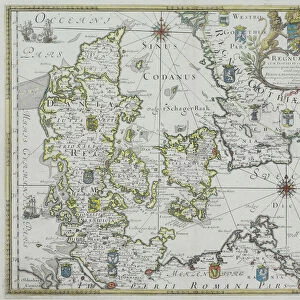
Fine Art Print : Map of Northern Europe, from Theatrum Orbis Terrarum by Abraham Ortelius, 1528-1598, 1570


![]()
Fine Art Prints from Universal Images Group (UIG)
Map of Northern Europe, from Theatrum Orbis Terrarum by Abraham Ortelius, 1528-1598, 1570
Cartography, 16th century. Map of Northern Europe, from Theatrum Orbis Terrarum by Abraham Ortelius (1528-1598), Antwerp, 1570
Universal Images Group (UIG) manages distribution for many leading specialist agencies worldwide
Media ID 9505609
© DEA / A. DAGLI ORTI
1570 16th Century Abraham Ortelius Aerial View Coastline Denmark Finland Greenland Guidance Iceland Island Latin Script Nautical Vessel Navigational Equipment Norway Peninsula River Sailing Ship Scandinavia Ship Sweden Text Theatrum Orbis Terrarum Non Urban Scene
A2 (42x59cm) Fine Art Print
Discover the rich history of cartography with our exquisite Fine Art Print of the Map of Northern Europe from Theatrum Orbis Terrarum by Abraham Ortelius. Dated back to 1570, this rare and intricately detailed map showcases the knowledge of the world during the 16th century. Produced by the renowned Flemish cartographer, this masterpiece is a must-have for history enthusiasts, cartography collectors, and those who appreciate the beauty of antique maps. Our high-quality Fine Art Prints are carefully reproduced from the original at Universal Images Group, ensuring the finest details and authenticity. Bring a piece of cartographic history into your home or office with this stunning addition to your collection.
Our Fine Art Prints are printed on 100% acid free, PH neutral paper with archival properties. This printing method is used by museums and art collections to exhibit photographs and art reproductions. Hahnemühle certified studio for digital fine art printing. Printed on 308gsm Photo Rag Paper.
Our fine art prints are high-quality prints made using a paper called Photo Rag. This 100% cotton rag fibre paper is known for its exceptional image sharpness, rich colors, and high level of detail, making it a popular choice for professional photographers and artists. Photo rag paper is our clear recommendation for a fine art paper print. If you can afford to spend more on a higher quality paper, then Photo Rag is our clear recommendation for a fine art paper print.
Estimated Image Size (if not cropped) is 53.4cm x 42cm (21" x 16.5")
Estimated Product Size is 59.4cm x 42cm (23.4" x 16.5")
These are individually made so all sizes are approximate
Artwork printed orientated as per the preview above, with landscape (horizontal) orientation to match the source image.
FEATURES IN THESE COLLECTIONS
> Maps and Charts
> Abraham Ortelius
> Universal Images Group (UIG)
> Art
> Painting, Sculpture & Prints
> Cartography
EDITORS COMMENTS
This print showcases a remarkable piece of cartography from the 16th century. The image features a Map of Northern Europe, meticulously crafted by Abraham Ortelius (1528-1598) and published in Antwerp in 1570 as part of his renowned work, Theatrum Orbis Terrarum. The map provides an intricate depiction of the topography and physical geography of the region, encompassing countries such as Finland, Sweden, Denmark, Norway, Iceland, and even Greenland. Its detailed illustrations highlight rivers snaking through lush landscapes while coastlines gracefully meet with vast bodies of water. A sailing ship gracefully glides across the sea on its journey through these northern European waters. This aerial view offers a glimpse into how navigational equipment was utilized during this era for safe passage along treacherous coastlines. The Latin script accompanying the map serves as both guidance and historical documentation. It transports us back to a time when exploration and discovery were at their peak. Through this artful representation captured in this print by Universal Images Group (UIG), we are reminded of the rich history that lies within maps like these - not just as tools for navigation but also as works of art that encapsulate our understanding and perception of the world around us.
MADE IN THE UK
Safe Shipping with 30 Day Money Back Guarantee
FREE PERSONALISATION*
We are proud to offer a range of customisation features including Personalised Captions, Color Filters and Picture Zoom Tools
SECURE PAYMENTS
We happily accept a wide range of payment options so you can pay for the things you need in the way that is most convenient for you
* Options may vary by product and licensing agreement. Zoomed Pictures can be adjusted in the Basket.