Metal Print > Historic > Ancient civilizations > Roman Empire > Ancient Rome
Metal Print : Ancient Rome, map of Roman Empire, illustration


![]()
Metal Prints from Universal Images Group (UIG)
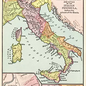
Ancient Rome, map of Roman Empire, illustration
Cartography - Ancient Rome, map of Roman Empire during the 3rd century, illustration
Universal Images Group (UIG) manages distribution for many leading specialist agencies worldwide
Media ID 9469977
3rd Century Ancient Art Dividing Empire Mediterranean Sea Roman
15"x10" (38x25cm) Metal Print
Step back in time with Media Storehouse's Metal Prints, featuring stunning imagery of Ancient Rome. This collection showcases a captivating map of the Roman Empire during the 3rd century, meticulously illustrated by Universal Images Group (UIG). Each print is expertly crafted on high-quality metal, enhancing the intricate details of the ancient cartography and bringing the grandeur of Rome's historic territory to life. Add an authentic and timeless touch to your decor with Media Storehouse's Ancient Rome Metal Prints.
Your image is printed photographically and bonded to a 3.5mm thick, Dibond board (black polyethylene sandwiched between two sheets of white coated aluminium). The panel is then sealed with a gloss protective covering. Supplied complete with a wall mount which holds the print 10mm from the wall.
Made with durable metal and luxurious printing techniques, metal prints bring images to life and add a modern touch to any space
Estimated Product Size is 38.1cm x 25.4cm (15" x 10")
These are individually made so all sizes are approximate
Artwork printed orientated as per the preview above, with landscape (horizontal) or portrait (vertical) orientation to match the source image.
FEATURES IN THESE COLLECTIONS
> Arts
> Artists
> R
> Roman Roman
> Europe
> Italy
> Lazio
> Rome
> Historic
> Ancient civilizations
> Roman Empire
> Ancient Rome
> Historic
> Ancient civilizations
> Roman Empire
> Roman art
> Historic
> Ancient civilizations
> Roman Empire
> Historic
> Ancient civilizations
> Maps and Charts
> Early Maps
> Maps and Charts
> Related Images
> Universal Images Group (UIG)
> Art
> Archeology
EDITORS COMMENTS
This print showcases a meticulously detailed map of the Roman Empire during its glorious 3rd century. A true testament to the ancient civilization's vast reach and power, this illustration takes us on a journey through time, immersing us in the rich history and geography of Ancient Rome. The empire's boundaries are clearly defined, stretching from Britannia in the northwest to Mesopotamia in the east, while encompassing diverse regions such as Gaul, Hispania, Africa Proconsularis, and Egypt along the way. The horizontal composition allows for an immersive experience as we trace our fingers across this antique masterpiece. The Mediterranean Sea acts as a central divide between Europe and Africa, serving as both a strategic advantage for trade routes and an emblematic symbol of Rome's dominance over these lands. As we gaze upon this ancient art form brought to life through cartography and illustration techniques, it is impossible not to be transported back in time. This print serves as a window into the past - an opportunity to explore one of history's greatest empires with awe-inspiring detail. With no people present within this image, our focus is solely on appreciating the craftsmanship behind this historical artifact. Whether displayed within educational institutions or personal collections dedicated to preserving human heritage, this remarkable piece offers endless opportunities for exploration and appreciation of Ancient Rome's legacy.
MADE IN THE UK
Safe Shipping with 30 Day Money Back Guarantee
FREE PERSONALISATION*
We are proud to offer a range of customisation features including Personalised Captions, Color Filters and Picture Zoom Tools
SECURE PAYMENTS
We happily accept a wide range of payment options so you can pay for the things you need in the way that is most convenient for you
* Options may vary by product and licensing agreement. Zoomed Pictures can be adjusted in the Basket.