Metal Print > Europe > United Kingdom > England > London > Politics > William Cavendish
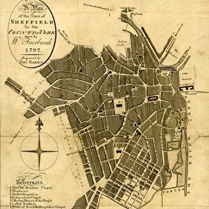
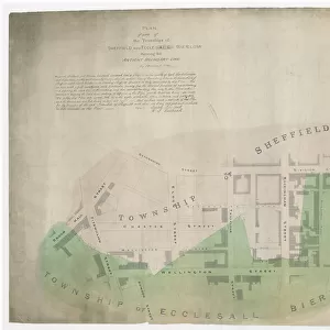
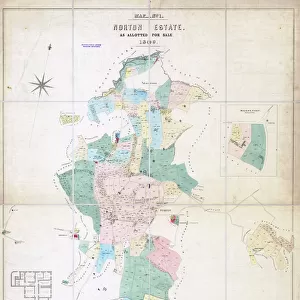
Metal Print : Plan shewing the antient [sic] boundary line between part of the townships of Sheffield, Ecclesall and Nether Hallam, 1834
![Plan shewing the antient [sic] boundary line between part of the townships of Sheffield, Ecclesall and Nether Hallam, 1834](/image/716/23122477/23122477_600_600_81370_0_fill_0_c3549608b7d32860b0b7cc388ff5c140.jpg.webp "Plan shewing the antient [sic] boundary line between part of the townships of Sheffield, Ecclesall and Nether Hallam, 1834")


![]()
Metal Prints from Sheffield City Archives
Plan shewing the antient [sic] boundary line between part of the townships of Sheffield, Ecclesall and Nether Hallam, 1834
Signed by Josiah Fairbank and William Fairbank Fairbank.
Also signed by W. Smith, Joshua Denton, Thomas Turner and Joseph Senior, Overseers of the Poor of Sheffield and Josiah Davy, John Smith, Samuel Mitchell and John Ward, Overseers of the Poor of Ecclesall Bierlow.
Shows Broad Lane, Pitt Street, Clarkson Street, Nelson Place, Sheffield and Glossop Turnpike, Brunswick Street, Wilkinson Street, Conway Street, Gell Street, Spring Lane, Spring Place, Cavendish Street, and Broom Hall Street.
Dimensions of original approx. 140 x 54 cm.
From an original at Sheffield Libraries: arc04049
Sheffield City Archives and Local Studies Library has an unrivalled collection of images of Sheffield, England
Media ID 23122477
© Sheffield City Council - All Rights Reserved
15"x10" (38x25cm) Metal Print
Step back in time with our exclusive Media Storehouse Metal Print featuring an intriguing historical map. This antique plan, dated 1834 from Sheffield City Archives, showcases the ancient boundary line between the townships of Sheffield, Ecclesall, and Nether Hallam. Signed by prominent local figures including Josiah Fairbank and William Fairbank Fairbank, W. Smith, Joshua Denton, Thomas Turner, Joseph Senior, and Josiah Davy, this collectible piece offers a unique glimpse into Sheffield's rich history. Display this stunning metal print in your home or office to add character and conversation-starting appeal.
Your image is printed photographically and bonded to a 3.5mm thick, Dibond board (black polyethylene sandwiched between two sheets of white coated aluminium). The panel is then sealed with a gloss protective covering. Supplied complete with a wall mount which holds the print 10mm from the wall.
Made with durable metal and luxurious printing techniques, metal prints bring images to life and add a modern touch to any space
Estimated Product Size is 38.1cm x 25.4cm (15" x 10")
These are individually made so all sizes are approximate
Artwork printed orientated as per the preview above, with landscape (horizontal) or portrait (vertical) orientation to match the source image.
FEATURES IN THESE COLLECTIONS
> Arts
> Artists
> L
> Samuel Lane
> Arts
> Artists
> S
> John Thomas Smith
> Arts
> Artists
> William Turner
> Europe
> United Kingdom
> England
> London
> Politics
> William Cavendish
> Europe
> United Kingdom
> England
> London
> Politics
> William Pitt
> Europe
> United Kingdom
> England
> Yorkshire
> Denton
> Europe
> United Kingdom
> England
> Yorkshire
> Related Images
> Europe
> United Kingdom
> England
> Yorkshire
> Sheffield
> Europe
> United Kingdom
> England
> Yorkshire
> Street
> Maps and Charts
> Related Images
> Sheffield City Archives
> Maps and Plans
> Maps of Sheffield
EDITORS COMMENTS
This print showcases a historical map titled "Plan shewing the antient boundary line between part of the townships of Sheffield, Ecclesall and Nether Hallam, 1834". Signed by esteemed individuals Josiah Fairbank and William Fairbank Fairbank, as well as W. Smith, Joshua Denton, Thomas Turner, Joseph Senior from Sheffield and Josiah Davy, John Smith, Samuel Mitchell, and John Ward from Ecclesall Bierlow who served as Overseers of the Poor. The intricate details depicted on this map offer a glimpse into the past with its representation of various streets such as Broad Lane, Pitt Street, Clarkson Street, Nelson Place in Sheffield. Additionally featured are Glossop Turnpike alongside Brunswick Street, Wilkinson Street Conway Street in Ecclesall Bierlow. Noteworthy landmarks like Gell Street Spring Lane Spring Place Cavendish Street and Broom Hall Street are also highlighted. Measuring approximately 140 x 54 cm in its original form; this remarkable piece is preserved at Sheffield Libraries under reference arc04049. A treasure trove for history enthusiasts or those seeking to explore the evolution of these townships over time
MADE IN THE UK
Safe Shipping with 30 Day Money Back Guarantee
FREE PERSONALISATION*
We are proud to offer a range of customisation features including Personalised Captions, Color Filters and Picture Zoom Tools
SECURE PAYMENTS
We happily accept a wide range of payment options so you can pay for the things you need in the way that is most convenient for you
* Options may vary by product and licensing agreement. Zoomed Pictures can be adjusted in the Basket.


![Plan of Owlerton Hall estate, Sheffield [1825]](/sq/716/plan-owlerton-hall-estate-sheffield-1825-21076344.jpg.webp)