Metal Print > Sheffield City Archives > Maps and Plans > Maps of Sheffield
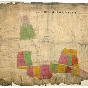
Metal Print : Plan of several estates in the townships of Ecclesall Bierlow and Nether Hallam


![]()
Metal Prints from Sheffield City Archives
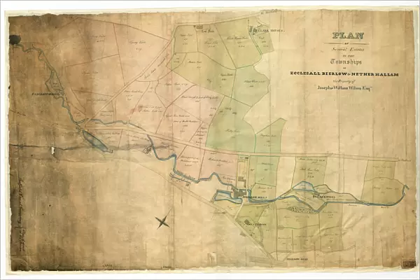
Plan of several estates in the townships of Ecclesall Bierlow and Nether Hallam
Full title: Plan of several estates in the townships of Ecclesall Bierlow and Nether Hallam, the property of Joseph and William Wilson.
Dated [c. 1825-1830]
Porter Brook, Long Field, Square Field, Spring Field, Brocco Bank Allotment, Upper Field, House Field, Tom Field [House], Clark House [sic] Field, Endcliff [sic] Wheel, pingle, Brocco Bank Close, Nether Field, Middle Field, Lower Delf Field, Upper Delph Field, Little Tom Field and part of Nether Field, Wheat Close, Wood Rough and part of Hilly Field, Great Tom Field and part of Halls Meadow, [River Porter], toll bar [Hunters Bar, Endcliffe Park, Ecclesall Road, Brocco Bank, Sharrow Vale], Upper Walsh Stubbing, Lower Walsh Stubbing, Halls Meadow, Lower part of the Meadow, Holme and Meadow, Bagshaw Field, Hilly Field, Meadow Spot, Sharrow Mill, dam and banks, West Brook, Stalker Wheel, Bank Close, House Close, House Field, North Shaw Field, Middle Stalker Lees, Upper South Shaw Field, Lower South Shaw Field, Lower Shaw Field, Breiry Holme, West Shaw Field, East Shaw Field, Upper Shaw Field.
[Covers the following area: Snuff Mill Lane, Stalker Lees Road, General Cemetery, Rosedale Road, Cemetery Avenue, Harefield Road, Denham Road, Harland Road, Neill Road, Eastwood Road. Meadow Terrace, Clarkehouse Road, Botanical Gardens, Endcliffe Vale Road, Botanical Road, Rossington Road, Wiseton Road, Newington Road, Endliffe Terrace Road, Endcliffe Rise Road, Wilson Road, Dover Road, Wadbrough Road, Southgrove Road, Broomgrove Road, Collegiate Crescent, Thompson Road, Khartoum Road, Walton Road, Bristol Road, Bagshot Street, Bruce Road, Westbrook Bank, Stewart Road, Ratcliffe Road, Jarrow Road, Gordon Road, Lynton Road, Wayland Road, Bowood Road].
Original at Sheffield Libraries: arc03951
Sheffield City Archives and Local Studies Library has an unrivalled collection of images of Sheffield, England
Media ID 20503347
© Sheffield City Council - All Rights Reserved
Archives Ecclesall Maps Sheffield Yorkshire
15"x10" (38x25cm) Metal Print
Bring history into your home with our stunning Metal Prints from Media Storehouse. This particular piece showcases an intriguing Plan of several estates in the townships of Ecclesall Bierlow and Nether Hallam, dating back to [c]. Originating from Sheffield City Archives, this detailed map once belonged to Joseph and William Wilson. Each Metal Print is meticulously printed on high-quality metal sheets using a sublimation process, ensuring vibrant colors and long-lasting durability. The sleek, modern design of the metal adds a unique touch to any space, making it a perfect conversation starter. Relive the past and add a touch of history to your décor with this captivating Metal Print from Media Storehouse.
Your image is printed photographically and bonded to a 3.5mm thick, Dibond board (black polyethylene sandwiched between two sheets of white coated aluminium). The panel is then sealed with a gloss protective covering. Supplied complete with a wall mount which holds the print 10mm from the wall.
Made with durable metal and luxurious printing techniques, metal prints bring images to life and add a modern touch to any space
Estimated Product Size is 38.1cm x 25.4cm (15" x 10")
These are individually made so all sizes are approximate
Artwork printed orientated as per the preview above, with landscape (horizontal) or portrait (vertical) orientation to match the source image.
EDITORS COMMENTS
This print showcases the detailed "Plan of several estates in the townships of Ecclesall Bierlow and Nether Hallam" which belonged to Joseph and William Wilson. Dating back to approximately 1825-1830, this historical document provides a fascinating glimpse into the past. The plan encompasses an extensive range of areas, including Porter Brook, Long Field, Square Field, Spring Field, Brocco Bank Allotment, Upper Field, House Field, Tom Field [House], Clark House [sic] Field, Endcliff [sic] Wheel, pingle, Brocco Bank Close, Nether Field, Middle Field, Lower Delf Field. It also covers significant landmarks such as Halls Meadow and Sharrow Mill. Stretching across Snuff Mill Lane to Bowood Road and beyond in Sheffield's vibrant landscape; it encapsulates key locations like Hunters Bar toll bar and Ecclesall Road. The plan even extends its reach towards notable sites like Botanical Gardens and Collegiate Crescent. Preserved at Sheffield Libraries: arc03951 from the Sheffield City Archives collection (not affiliated with any company), this print offers a valuable resource for historians and enthusiasts alike.
MADE IN THE UK
Safe Shipping with 30 Day Money Back Guarantee
FREE PERSONALISATION*
We are proud to offer a range of customisation features including Personalised Captions, Color Filters and Picture Zoom Tools
SECURE PAYMENTS
We happily accept a wide range of payment options so you can pay for the things you need in the way that is most convenient for you
* Options may vary by product and licensing agreement. Zoomed Pictures can be adjusted in the Basket.


![Plan of an enlargement of the [General] Cemetery and of a new road leading thereto, in the township of Ecclesall Bierlow within the parish of Sheffield, 1846](/sq/716/plan-enlargement-general-cemetery-new-road-14046488.jpg.webp)