Metal Print : John Speeds map of Rutland, 1611


![]()
Metal Prints From Sheffield City Archives
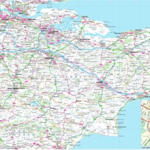
John Speeds map of Rutland, 1611
Image from Theatre of the Empire of Great Britaine presenting an exact geography of the Kingdomes of Ireland, Scotland, Ireland, and the Iles adioyning with The Shires, Hundreds, Cities and Shire Towns, within ye Kingdome of England, divided and described by John Speed (original at Sheffield Libraries: 914.2 SQ).
Note this image is of a genuine 400-year-old map from a tightly bound volume. It shows some wear and tear as well as the binding in the middle of the image
Sheffield City Archives and Local Studies Library has an unrivalled collection of images of Sheffield, England
Media ID 26401408
© Sheffield City Council - All Rights Reserved
20"x16" (51x41cm) Metal Print
Discover history in a new light with Media Storehouse Metal Prints. This exquisite piece features John Speed's 1611 map of Rutland from the Sheffield City Archives. Known as "Theatre of the Empire of Great Britaine," this map is a testament to the intricate detail and historical significance of the time. Each Metal Print is meticulously crafted, preserving the authenticity and beauty of the original map. Hang it in your home or office as a conversation starter and a reminder of the rich history that surrounds us. Experience the past like never before with Media Storehouse Metal Prints.
Your image is printed photographically and bonded to a 3.5mm thick, Dibond board (black polyethylene sandwiched between two sheets of white coated aluminium). The panel is then sealed with a gloss protective covering. Supplied complete with a wall mount which holds the print 10mm from the wall.
Made with durable metal and luxurious printing techniques, metal prints bring images to life and add a modern touch to any space
Estimated Product Size is 50.8cm x 40.6cm (20" x 16")
These are individually made so all sizes are approximate
Artwork printed orientated as per the preview above, with landscape (horizontal) or portrait (vertical) orientation to match the source image.
EDITORS COMMENTS
This print showcases John Speed's map of Rutland, dating back to 1611. Extracted from the renowned "Theatre of the Empire of Great Britaine" this image offers a glimpse into the exact geography of England during that era. Preserved within Sheffield Libraries, this genuine 400-year-old map is a testament to both its historical significance and enduring beauty. Despite its age, the wear and tear evident on the map only adds to its charm and authenticity. The binding in the middle serves as a tangible reminder of how these maps were once cherished possessions, carefully stored within tightly bound volumes. As we admire this photograph, we are transported back in time to an era when cartography was still evolving and exploration was at its peak. John Speed's meticulous attention to detail is evident in every inch of this map. From shires to hundreds, cities to shire towns, he masterfully captures the essence of Rutland's landscape with precision and accuracy. This snapshot allows us to appreciate not only his skill as a cartographer but also provides valuable insights into England's past. As we gaze upon this remarkable piece from Sheffield City Archives, let us marvel at how far our understanding of geography has come since 1611 while simultaneously cherishing these remnants from centuries gone by.
MADE IN THE UK
Safe Shipping with 30 Day Money Back Guarantee
FREE PERSONALISATION*
We are proud to offer a range of customisation features including Personalised Captions, Color Filters and Picture Zoom Tools
SECURE PAYMENTS
We happily accept a wide range of payment options so you can pay for the things you need in the way that is most convenient for you
* Options may vary by product and licensing agreement. Zoomed Pictures can be adjusted in the Basket.