Metal Print > Historic > Ancient civilizations > Ancient Greece > Greek history
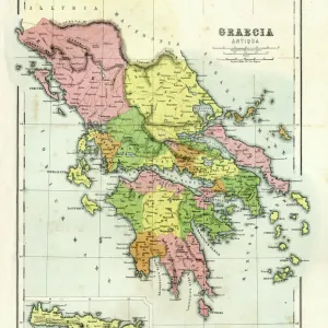
Metal Print : Map of Ancient Greece


![]()
Metal Prints from Mary Evans Picture Library
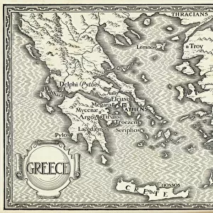
Map of Ancient Greece
A map showing the extent of the Greek Empire and the surrounding territories
Mary Evans Picture Library makes available wonderful images created for people to enjoy over the centuries
Media ID 600235
© Mary Evans Picture Library 2015 - https://copyrighthub.org/s0/hub1/creation/maryevans/MaryEvansPictureID/10137108
Civilisation Extensive Extent Maps Regions Surrounding Territories
15"x10" (38x25cm) Metal Print
Discover the rich history of Ancient Greece with our stunning Metal Prints from Media Storehouse. Featuring this intricately detailed Map of Ancient Greece from Mary Evans Picture Library, these prints bring history to life with their vibrant colors and high-quality metallic finish. Perfect for adding a touch of ancient wisdom to your home or office, each print is printed on premium metal sheets using state-of-the-art technology for a sleek, modern look. Explore the vast expanse of the Greek Empire and surrounding territories with this beautiful and educational piece of wall art. Order yours today and bring a piece of history into your space.
Your image is printed photographically and bonded to a 3.5mm thick, Dibond board (black polyethylene sandwiched between two sheets of white coated aluminium). The panel is then sealed with a gloss protective covering. Supplied complete with a wall mount which holds the print 10mm from the wall.
Made with durable metal and luxurious printing techniques, metal prints bring images to life and add a modern touch to any space
Estimated Product Size is 38.1cm x 25.4cm (15" x 10")
These are individually made so all sizes are approximate
Artwork printed orientated as per the preview above, with landscape (horizontal) or portrait (vertical) orientation to match the source image.
FEATURES IN THESE COLLECTIONS
> Mary Evans Prints Online
> Maps
> Europe
> Greece
> Related Images
> Europe
> Related Images
> Historic
> Ancient civilizations
> Ancient Greece
> Greek history
> Maps and Charts
> Early Maps
> Maps and Charts
> Popular Maps
> Maps and Charts
> Related Images
> Popular Themes
> Maps and Charts
EDITORS COMMENTS
This stunning print of a "Map of Ancient Greece" from Mary Evans Picture Library offers a fascinating glimpse into the extensive reach of the Greek Empire and its surrounding territories. The intricate details on this historical map showcase the various city-states, regions, and states that made up this ancient civilization dating back to 500 BC.
From Athens to Sparta, this map highlights key cities and landmarks that played significant roles in shaping Greek history and culture. It also illustrates how far-reaching the influence of the Greek Empire was throughout Europe during this time period.
As you study each line and boundary on this map, you can't help but feel transported back in time to an era where philosophy, art, and democracy flourished in these lands. The rich history depicted on this map serves as a reminder of the legacy left behind by one of the most influential civilizations in world history.
Whether you're a history buff or simply appreciate beautiful cartography, this "Map of Ancient Greece" print is sure to spark your curiosity and imagination. Display it proudly in your home or office as a conversation piece that celebrates the enduring impact of ancient Greek civilization.
MADE IN THE UK
Safe Shipping with 30 Day Money Back Guarantee
FREE PERSONALISATION*
We are proud to offer a range of customisation features including Personalised Captions, Color Filters and Picture Zoom Tools
SECURE PAYMENTS
We happily accept a wide range of payment options so you can pay for the things you need in the way that is most convenient for you
* Options may vary by product and licensing agreement. Zoomed Pictures can be adjusted in the Basket.