Metal Print > Europe > United Kingdom > Northern Ireland > County Down > Newcastle
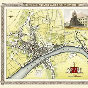
Metal Print : Old Map of Newcastle 1898 from the Royal Atlas by Bartholomew


![]()
Metal Prints from MapSeeker
Old Map of Newcastle 1898 from the Royal Atlas by Bartholomew
A fine very detailed plan of the City of Newcastle remastered from an original contained within " The Royal Atlas of England and Wales" ; edited by J.G. Bartholomew, published by George Newnes, Limited, London
Welcome to the Mapseeker Image library and enter an historic gateway to one of the largest on-line collections of Historic Maps, Nostalgic Views, Vista's and Panorama's from a World gone by.
Media ID 20347771
Bartholomew Bartholomew Map Historic Map Old Town Plan Royal Atlas Royal Atlas Map Newcastle Newcastle Upon Tyne
15"x10" (38x25cm) Metal Print
Step back in time with our exquisite Metal Print of the Old Map of Newcastle 1898 from the Royal Atlas by Bartholomew, available at Media Storehouse. This intricately detailed map, sourced from the original contained within "The Royal Atlas of England and Wales," offers a captivating glimpse into the history of Newcastle as it once was. Each metal print is meticulously remastered to bring out the finest lines and textures, resulting in a stunning, high-definition image that is sure to make a statement in any room. Experience the rich history of Newcastle like never before with our premium quality Metal Prints.
Your image is printed photographically and bonded to a 3.5mm thick, Dibond board (black polyethylene sandwiched between two sheets of white coated aluminium). The panel is then sealed with a gloss protective covering. Supplied complete with a wall mount which holds the print 10mm from the wall.
Made with durable metal and luxurious printing techniques, metal prints bring images to life and add a modern touch to any space
Estimated Product Size is 38.1cm x 25.4cm (15" x 10")
These are individually made so all sizes are approximate
Artwork printed orientated as per the preview above, with landscape (horizontal) or portrait (vertical) orientation to match the source image.
FEATURES IN THESE COLLECTIONS
> MapSeeker
> British Town And City Plans
> English & Welsh PORTFOLIO
> Arts
> Photorealistic artworks
> Detailed art pieces
> Masterful detailing in art
> Europe
> United Kingdom
> England
> London
> Royalty
> Europe
> United Kingdom
> England
> Maps
> Europe
> United Kingdom
> England
> Newcastle upon Tyne
> Europe
> United Kingdom
> Northern Ireland
> County Down
> Newcastle
> Europe
> United Kingdom
> Wales
> Maps
> Europe
> United Kingdom
> Wales
> Posters
> Maps and Charts
> Related Images
> Maps and Charts
> Wales
EDITORS COMMENTS
This beautifully preserved print showcases an exquisite piece of history - the Old Map of Newcastle from 1898. Remastered from an original contained within "The Royal Atlas of England and Wales" this fine and highly detailed plan offers a fascinating glimpse into the city's past. Published by George Newnes, Limited in London, and edited by J. G. Bartholomew, this map is a testament to the meticulous craftsmanship that went into cartography during that era. Every street, building, and landmark is intricately depicted, allowing us to trace the evolution of Newcastle upon Tyne. As we study this old town plan, we are transported back in time to a bustling cityscape filled with horse-drawn carriages traversing cobblestone streets. The River Tyne flows majestically through the heart of Newcastle as ships dock along its banks. This historic map not only serves as a valuable resource for researchers and historians but also evokes nostalgia among those who call Newcastle home. It reminds us of our roots and how far we have come since then. Displaying this print proudly on your wall will undoubtedly spark conversations about local history and ignite curiosity about our ancestors' lives in this vibrant city. Let it be a reminder that beneath our modern surroundings lies a rich tapestry woven with stories waiting to be discovered.
MADE IN THE UK
Safe Shipping with 30 Day Money Back Guarantee
FREE PERSONALISATION*
We are proud to offer a range of customisation features including Personalised Captions, Color Filters and Picture Zoom Tools
SECURE PAYMENTS
We happily accept a wide range of payment options so you can pay for the things you need in the way that is most convenient for you
* Options may vary by product and licensing agreement. Zoomed Pictures can be adjusted in the Basket.