Metal Print > Asia > Turkey > Related Images
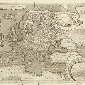
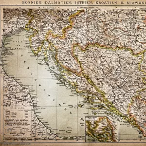
Metal Print : SAN STEFANO TREATY MAP. The first publication of the map showing the territorial


![]()
Metal Prints from Granger
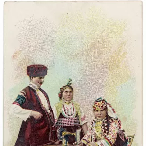
SAN STEFANO TREATY MAP. The first publication of the map showing the territorial
SAN STEFANO TREATY MAP.
The first publication of the map showing the territorial changes effected by the treaty between Russia and Turkey signed at San Stefano, 3 March 1878
Granger holds millions of images spanning more than 25,000 years of world history, from before the Stone Age to the dawn of the Space Age
Media ID 12414306
1878 Agaen Asia Black Sea Border Boundary Bulgaria Constantinople Hellenic Republic Hungary March Montenegro Ottoman Empire Romania Russia Russian Sarajevo Serbia Territory Treaty Turkish Adrianople Albania San Stefano
20"x20" (51x51cm) Metal Print
Discover history in a new light with Media Storehouse Metal Prints featuring the first publication of the San Stefano Treaty Map. This intriguing piece showcases the significant territorial changes resulting from the treaty signed between Russia and Turkey in 1878. With a vintage aesthetic from Granger Art on Demand, our high-quality metal prints bring history straight to your walls, adding an educational and captivating touch to any room. Experience the past in a modern and stylish way.
Your image is printed photographically and bonded to a 3.5mm thick, Dibond board (black polyethylene sandwiched between two sheets of white coated aluminium). The panel is then sealed with a gloss protective covering. Supplied complete with a wall mount which holds the print 10mm from the wall.
Made with durable metal and luxurious printing techniques, metal prints bring images to life and add a modern touch to any space
Estimated Product Size is 50.8cm x 50.8cm (20" x 20")
These are individually made so all sizes are approximate
Artwork printed orientated as per the preview above, with landscape (horizontal) or portrait (vertical) orientation to match the source image.
FEATURES IN THESE COLLECTIONS
> Granger Art on Demand
> World History
> Asia
> Turkey
> Related Images
> Europe
> Albania
> Related Images
> Europe
> Bulgaria
> Related Images
San Stefano Treaty Map - A Glimpse into Historical Territorial Changes
EDITORS COMMENTS
. This print showcases the first publication of the San Stefano Treaty map, revealing the significant territorial alterations resulting from the treaty signed between Russia and Turkey on 3 March 1878. The intricate details captured in this late 19th-century map offer a fascinating insight into the geopolitical landscape of that era. The map encompasses various regions such as Adrianople, Agaen, Albania, Asia, Black Sea, Black Salon, Bulgaria, Constantinople (now Istanbul), Hellenic Republic (Greece), Hungary, Montenegro, Ottoman Empire (Turkey), Romania, Russia and Sarajevo. It delineates borders and boundaries with precision while highlighting key cities and rivers within these territories. As one examines this historical artifact closely, it becomes evident how this treaty aimed to reshape Europe's power dynamics during a time of great political flux. The Russian influence is particularly notable as they sought to expand their dominion over vast areas previously under Ottoman control. This print serves as a reminder of the intricacies involved in international diplomacy during that period. It offers an opportunity for viewers to delve into history and gain a deeper understanding of how treaties like San Stefano shaped nations' destinies.
MADE IN THE UK
Safe Shipping with 30 Day Money Back Guarantee
FREE PERSONALISATION*
We are proud to offer a range of customisation features including Personalised Captions, Color Filters and Picture Zoom Tools
SECURE PAYMENTS
We happily accept a wide range of payment options so you can pay for the things you need in the way that is most convenient for you
* Options may vary by product and licensing agreement. Zoomed Pictures can be adjusted in the Basket.