Metal Print > Fine Art Storehouse > Map
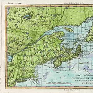
Metal Print : United States North East map 1897


![]()
Metal Prints from Fine Art Storehouse
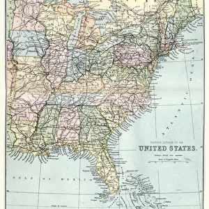
United States North East map 1897
The World-Wide Atlas of Modern Geography, Political and Physical W. & A.K. Johnston - London 1897
Unleash your creativity and transform your space into a visual masterpiece!
THEPALMER
Media ID 14457423
© Roberto A Sanchez
Atlantic Ocean Atlas Connecticut Country Geographic Area Earth Maine Massachusetts New York City New York State North America Northeast Paper Pennsylvania World Map Retro Styled
15"x10" (38x25cm) Metal Print
Step back in time with our exquisite Metal Print featuring an 1897 United States North East map by THEPALMER from the Fine Art Storehouse. This captivating piece, taken from The World-Wide Atlas of Modern Geography, Political and Physical W. & A.K. Johnston, London, showcases intricate details and vintage charm. The high-quality Metal Print preserves the rich history and intricacies of the map, making it a stunning addition to any home or office decor. Bring a piece of the past into your present with this unique and timeless piece.
Your image is printed photographically and bonded to a 3.5mm thick, Dibond board (black polyethylene sandwiched between two sheets of white coated aluminium). The panel is then sealed with a gloss protective covering. Supplied complete with a wall mount which holds the print 10mm from the wall.
Made with durable metal and luxurious printing techniques, metal prints bring images to life and add a modern touch to any space
Estimated Product Size is 25.4cm x 38.1cm (10" x 15")
These are individually made so all sizes are approximate
Artwork printed orientated as per the preview above, with landscape (horizontal) or portrait (vertical) orientation to match the source image.
FEATURES IN THESE COLLECTIONS
> Fine Art Storehouse
> Map
> Historical Maps
> Fine Art Storehouse
> Map
> USA Maps
EDITORS COMMENTS
This print takes us back in time to the year 1897, when cartography was a meticulous art form. The image showcases a vintage map of the United States' North East region, extracted from "The World-Wide Atlas of Modern Geography" by W. & A. K. Johnston - London 1897. With its retro styling and engraved details, this antique piece exudes an air of nostalgia and historical significance. The carefully crafted lines and intricate shading bring to life the physical geography of this particular area, encompassing states such as Massachusetts, Connecticut, Maine, New York City and State, Pennsylvania, among others. As we gaze upon this old-world treasure, it is impossible not to be transported into a different era—a time when paper maps were essential tools for exploration and understanding our world's vast landscapes. The map extends beyond just land boundaries; it also reveals glimpses of the Atlantic Ocean that borders this northeastern corner of the United States. Intriguingly detailed yet elegantly simplistic in design, this engraving serves as a reminder of how far we have come in terms of geographic knowledge and technological advancements. It invites us to appreciate both the beauty found within these ancient maps and their invaluable contribution to our understanding of Earth's diverse terrains. "The United States North East Map 1897" by THEPALMER is more than just an artistic representation—it encapsulates history itself through its delicate engravings on aged paper.
MADE IN THE UK
Safe Shipping with 30 Day Money Back Guarantee
FREE PERSONALISATION*
We are proud to offer a range of customisation features including Personalised Captions, Color Filters and Picture Zoom Tools
SECURE PAYMENTS
We happily accept a wide range of payment options so you can pay for the things you need in the way that is most convenient for you
* Options may vary by product and licensing agreement. Zoomed Pictures can be adjusted in the Basket.