Metal Print > Arts > Street art graffiti > Digital art > Vector illustrations
Metal Print : Brookings South Dakota US City Street Map


![]()
Metal Prints from Fine Art Storehouse
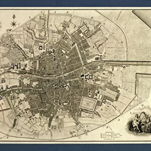
Brookings South Dakota US City Street Map
Vector Illustration of a City Street Map of Brookings, South Dakota, USA. Scale 1:60, 000.
All source data is in the public domain.
U.S. Geological Survey, US Topo
Used Layers:
USGS The National Map: National Hydrography Dataset (NHD)
USGS The National Map: National Transportation Dataset (NTD)
Unleash your creativity and transform your space into a visual masterpiece!
Frank Ramspott
Media ID 15215806
© Frank Ramspott, all rights reserved
Aerial View City Map Computer Graphic Directly Above Downtown District Gray Road Map South Dakota Text Brookings Digitally Generated Image Green Color White Color
20"x20" (51x51cm) Metal Print
Discover the charm of Brookings, South Dakota with our stunning Metal Print of the city street map by Frank Ramspott from Media Storehouse. This intricately detailed vector illustration, featuring a 1:60,000 scale representation of the city, is meticulously crafted from public domain data. Bring the essence of this vibrant US city into your home or office with the sleek, modern look of a Metal Print. Each print is meticulously printed and mounted on a lightweight, rust-resistant aluminum sheet, ensuring lasting brilliance and a contemporary finish. Experience the beauty of Brookings like never before with Media Storehouse's Metal Print.
Your image is printed photographically and bonded to a 3.5mm thick, Dibond board (black polyethylene sandwiched between two sheets of white coated aluminium). The panel is then sealed with a gloss protective covering. Supplied complete with a wall mount which holds the print 10mm from the wall.
Made with durable metal and luxurious printing techniques, metal prints bring images to life and add a modern touch to any space
Estimated Product Size is 50.8cm x 50.8cm (20" x 20")
These are individually made so all sizes are approximate
Artwork printed orientated as per the preview above, with landscape (horizontal) or portrait (vertical) orientation to match the source image.
FEATURES IN THESE COLLECTIONS
> Fine Art Storehouse
> Map
> Street Maps
> Fine Art Storehouse
> Map
> USA Maps
> Aerial Photography
> Related Images
> Animals
> Insects
> Hemiptera
> Green Scale
> Arts
> Contemporary art
> Digital artwork
> Street art
> Arts
> Landscape paintings
> Waterfall and river artworks
> River artworks
> Arts
> Portraits
> Pop art gallery
> Street art portraits
> Arts
> Street art graffiti
> Digital art
> Digital paintings
> Arts
> Street art graffiti
> Digital art
> Vector illustrations
> Maps and Charts
> Geological Map
> Maps and Charts
> Related Images
> North America
> United States of America
> Lakes
> Related Images
EDITORS COMMENTS
This print showcases a meticulously detailed vector illustration of the charming city street map of Brookings, South Dakota, USA. With a scale of 1:60,000, every intricate element is brought to life in this visually stunning artwork. The source data used for this masterpiece is all in the public domain and comes from reputable sources such as the U. S. Geological Survey and US Topo. The various layers utilized include the USGS National Hydrography Dataset (NHD) and National Transportation Dataset (NTD), ensuring accuracy and precision in depicting water bodies, roads, streets, and transportation networks within Brookings. The image encompasses not only the downtown district but also highlights other prominent features like lakes and rivers that add to the natural beauty of this vibrant city. The digitally generated design presents an aerial view directly above Brookings with text labels elegantly incorporated into shades of gray, blue, white, and green colors. With no people present in this composition, it allows viewers to focus solely on appreciating the artistry behind this cartographic marvel. This print by Frank Ramspott captures both physical geography and computer graphics seamlessly merged together. Perfect for enthusiasts of maps or those with a connection to Brookings or South Dakota's rich history - this fine art piece will surely make a striking addition to any space it graces.
MADE IN THE UK
Safe Shipping with 30 Day Money Back Guarantee
FREE PERSONALISATION*
We are proud to offer a range of customisation features including Personalised Captions, Color Filters and Picture Zoom Tools
SECURE PAYMENTS
We happily accept a wide range of payment options so you can pay for the things you need in the way that is most convenient for you
* Options may vary by product and licensing agreement. Zoomed Pictures can be adjusted in the Basket.