Metal Print > Africa > Egypt > Maps
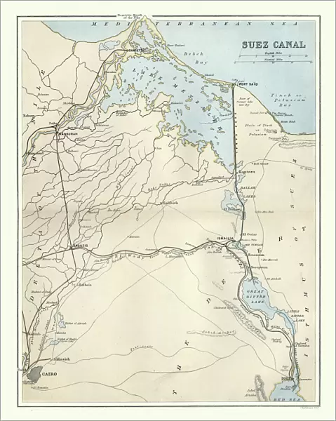
Metal Print : Antique map of Suez Canal, Egypt, 1880s, 19th Century


![]()
Metal Prints from Fine Art Storehouse
Antique map of Suez Canal, Egypt, 1880s, 19th Century
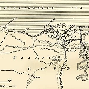
Vintage engraving of Antique map of Suez Canal, Egypt, 1880s, 19th Century. The Suez Canal is a sea-level waterway in Egypt, connecting the Mediterranean Sea to the Red Sea through the Isthmus of Suez
Unleash your creativity and transform your space into a visual masterpiece!
duncan1890
Media ID 19684343
© of Duncan P Walker
20"x16" (51x41cm) Metal Print
Step back in time with our stunning Metal Print of an Antique Map of the Suez Canal, Egypt, from the 1880s. This vintage engraving, sourced from the Fine Art Storehouse by duncan1890, transports you to the 19th century with intricate details and authentic charm. The Suez Canal, depicted as a sea-level waterway in Egypt, is beautifully rendered in this metal print, making it a unique and captivating addition to any home or office decor. Elevate your space with a piece of history that tells a story. Order now and let the allure of the past come alive in your surroundings.
Your image is printed photographically and bonded to a 3.5mm thick, Dibond board (black polyethylene sandwiched between two sheets of white coated aluminium). The panel is then sealed with a gloss protective covering. Supplied complete with a wall mount which holds the print 10mm from the wall.
Made with durable metal and luxurious printing techniques, metal prints bring images to life and add a modern touch to any space
Estimated Product Size is 40.6cm x 50.8cm (16" x 20")
These are individually made so all sizes are approximate
Artwork printed orientated as per the preview above, with landscape (horizontal) or portrait (vertical) orientation to match the source image.
FEATURES IN THESE COLLECTIONS
> Fine Art Storehouse
> Map
> Historical Maps
> Africa
> Egypt
> Related Images
> Maps and Charts
> Related Images
EDITORS COMMENTS
This print showcases an exquisite antique map of the Suez Canal, Egypt, dating back to the 1880s. A true relic from the 19th century, this vintage engraving beautifully captures the intricate details and historical significance of this remarkable waterway. The Suez Canal itself is a sea-level passage located in Egypt, serving as a vital link between the Mediterranean Sea and the Red Sea through the Isthmus of Suez. As we gaze upon this stunning piece of art, we are transported back in time to an era where exploration and trade routes shaped our world. The delicate lines and meticulous craftsmanship on display here highlight not only the technical prowess of cartographers during that period but also their deep understanding of geography. The Suez Canal has played a pivotal role in global commerce for centuries, facilitating international trade by providing ships with a direct route between Europe and Asia. This antique map serves as a testament to human ingenuity and determination to conquer nature's obstacles. With its warm sepia tones and aged appearance, this print evokes nostalgia while reminding us of how far we have come since its creation. It stands as both a work of art and an important historical document that allows us to appreciate the past while contemplating our future journeys through these iconic waters.
MADE IN THE UK
Safe Shipping with 30 Day Money Back Guarantee
FREE PERSONALISATION*
We are proud to offer a range of customisation features including Personalised Captions, Color Filters and Picture Zoom Tools
SECURE PAYMENTS
We happily accept a wide range of payment options so you can pay for the things you need in the way that is most convenient for you
* Options may vary by product and licensing agreement. Zoomed Pictures can be adjusted in the Basket.