Home > Maps and Charts > Early Maps
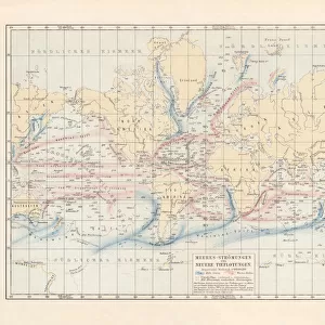
Arctic Ocean and adjacent countries, lithograph, published in 1897

![]()
Wall Art and Photo Gifts from Fine Art Storehouse
Arctic Ocean and adjacent countries, lithograph, published in 1897
Topographic map of the Arctic Ocean and adjacent countries more than 100 years ago. With information of the Arctic expeditions of the 19th century. Lithograph, published in 1897
Unleash your creativity and transform your space into a visual masterpiece!
ZU_09
Media ID 18106731
FEATURES IN THESE COLLECTIONS
> Fine Art Storehouse
> Map
> Historical Maps
> Maps and Charts
> Early Maps
EDITORS COMMENTS
This lithograph, published in 1897, offers a mesmerizing glimpse into the Arctic Ocean and its adjacent countries over a century ago. The intricate topographic map showcases the vast expanse of this remote region, revealing an untouched landscape that was yet to be fully explored. With meticulous detail and precision, it provides valuable information about the various Arctic expeditions undertaken during the 19th century. The print transports us back in time, allowing us to imagine the brave explorers who ventured into these icy waters in search of new discoveries and scientific knowledge. It serves as a testament to their courage and determination in facing the harsh conditions of this unforgiving environment. As we study this lithograph, we are reminded of how much our understanding of the Arctic has evolved since then. Today, technological advancements have enabled us to explore and document this unique part of our planet with greater accuracy. Yet there is still an air of mystery surrounding these frozen lands that continues to captivate our imagination. Whether you are an avid historian or simply intrigued by the beauty and intrigue of maps from yesteryears, this print is sure to spark curiosity and transport you on a visual journey through time. It stands as both a historical artifact and a work of art – preserving not only geographical information but also evoking emotions tied to exploration, adventure, and human resilience against nature's formidable forces.
MADE IN THE UK
Safe Shipping with 30 Day Money Back Guarantee
FREE PERSONALISATION*
We are proud to offer a range of customisation features including Personalised Captions, Color Filters and Picture Zoom Tools
SECURE PAYMENTS
We happily accept a wide range of payment options so you can pay for the things you need in the way that is most convenient for you
* Options may vary by product and licensing agreement. Zoomed Pictures can be adjusted in the Basket.