
Metal Print > Fine Art Storehouse > Map
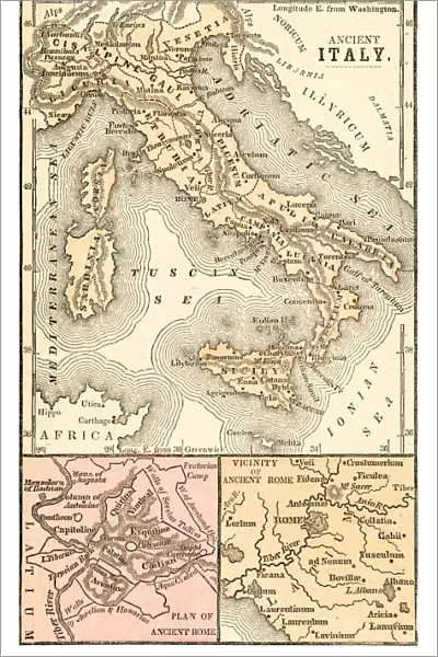
Metal Print : Ancient Italy map 1875


![]()
Metal Prints from Fine Art Storehouse
Ancient Italy map 1875
The Independent Course Comprehensive Geography by James Monteith, A.S. Barnes & Co, New York & Chicago 1875
Unleash your creativity and transform your space into a visual masterpiece!
THEPALMER
Media ID 13612255
© This content is subject to copyright
Ancient History Globe Navigational Equipment Paper Roman Sicily Ancient Italy
15"x10" (38x25cm) Metal Print
Step back in time with our exquisite Ancient Italy Metal Print from Media Storehouse's Fine Art Collection. This captivating map, titled "Italy: Map of Ancient Italy from The Independent Course of Geography, by James Monteith, A.S. Barnes & Co, New York & Chicago, 1875," is beautifully reproduced on a high-quality metal print. The intricate details of this 1875 map of Ancient Italy by THEPALMER are brought to life through our unique process, which infuses the image into a sturdy and durable metal panel. Hang this stunning piece in your home or office as a conversation starter and a reminder of the rich history that lies within. This metal print is not just a decorative piece, but a journey through time, perfect for history enthusiasts, geography buffs, or anyone who appreciates the beauty of vintage maps.
Your image is printed photographically and bonded to a 3.5mm thick, Dibond board (black polyethylene sandwiched between two sheets of white coated aluminium). The panel is then sealed with a gloss protective covering. Supplied complete with a wall mount which holds the print 10mm from the wall.
Made with durable metal and luxurious printing techniques, metal prints bring images to life and add a modern touch to any space
Estimated Product Size is 25.4cm x 38.1cm (10" x 15")
These are individually made so all sizes are approximate
Artwork printed orientated as per the preview above, with landscape (horizontal) or portrait (vertical) orientation to match the source image.
FEATURES IN THESE COLLECTIONS
> Fine Art Storehouse
> The Magical World of Illustration
> Palmer Illustrated Collection
> Fine Art Storehouse
> Map
> Historical Maps
> Fine Art Storehouse
> Map
> Italian Maps
EDITORS COMMENTS
This print takes us on a journey back in time to Ancient Italy, as depicted in the comprehensive geography book by James Monteith. The map, published in 1875 by A. S. Barnes & Co. , transports us to an era where cartography was painstakingly engraved onto paper with intricate detail and precision. The image showcases the rich history of Italy, from its iconic boot-shaped peninsula to the enchanting island of Sicily. Every contour and boundary is meticulously etched, allowing us to explore the physical geography of this ancient land. As we examine this antique engraving, we are reminded of how far our navigational equipment has come since then - from globes to GPS systems. The Roman influence is evident throughout this historical snapshot; it serves as a reminder of their once-great empire that stretched across much of Europe. The illustration captures not only the political boundaries but also offers insights into the cultural heritage and significance of each region. As we delve into this remarkable piece created by THEPALMER for Fine Art Storehouse, we can't help but marvel at its timeless beauty. It serves as a testament to human curiosity and our unending quest for knowledge about our past. This print invites us to immerse ourselves in ancient history through cartography – a window into worlds long gone yet forever preserved on paper.
MADE IN THE UK
Safe Shipping with 30 Day Money Back Guarantee
FREE PERSONALISATION*
We are proud to offer a range of customisation features including Personalised Captions, Color Filters and Picture Zoom Tools
SECURE PAYMENTS
We happily accept a wide range of payment options so you can pay for the things you need in the way that is most convenient for you
* Options may vary by product and licensing agreement. Zoomed Pictures can be adjusted in the Basket.


