Metal Print > Fine Art Storehouse > Map
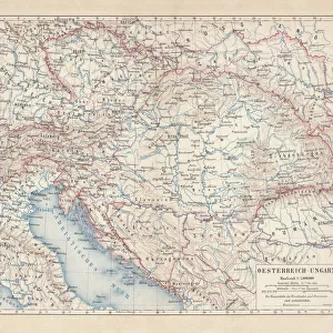
Metal Print : Mecklenburg and Pomerania


![]()
Metal Prints from Fine Art Storehouse
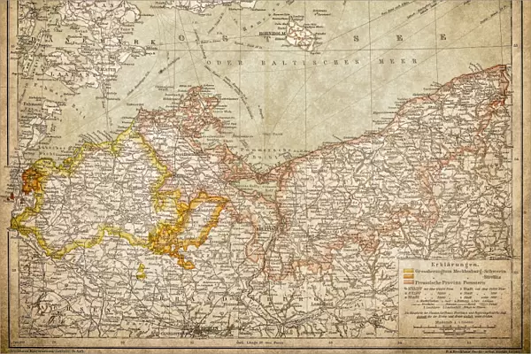
Mecklenburg and Pomerania
Ancient map of Mecklenburg and Pomerania
Unleash your creativity and transform your space into a visual masterpiece!
Nastasic
Media ID 13593315
© Nikola Nastasic
78279 Baltic Sea Berlin Cartographer Contour Drawing European Culture Fischland Darß Zingst German Culture German Empire Island Mecklenburg Vorpommern Poland Polish Culture Pomerania Prussia Rugen Stralsund Topographic Map Topography Deutsches Reich Image Created 19th Century Obsolete Pommern Rugen Island Usedom
15"x10" (38x25cm) Metal Print
Discover the rich history of Mecklenburg and Pomerania with our stunning Metal Print of the ancient map by Nastasic, available at Fine Art Storehouse. This exquisite piece of art showcases intricate details of the regions' historical borders and topography. The high-quality Metal Print process ensures vibrant colors and a sleek, modern look that adds an elegant touch to any space. Bring history to life in your home or office with this beautiful and unique decorative piece.
Your image is printed photographically and bonded to a 3.5mm thick, Dibond board (black polyethylene sandwiched between two sheets of white coated aluminium). The panel is then sealed with a gloss protective covering. Supplied complete with a wall mount which holds the print 10mm from the wall.
Made with durable metal and luxurious printing techniques, metal prints bring images to life and add a modern touch to any space
Estimated Product Size is 38.1cm x 25.4cm (15" x 10")
These are individually made so all sizes are approximate
Artwork printed orientated as per the preview above, with landscape (horizontal) or portrait (vertical) orientation to match the source image.
FEATURES IN THESE COLLECTIONS
> Fine Art Storehouse
> The Magical World of Illustration
> Nastasic Images & Illustrations
> Fine Art Storehouse
> Map
> Historical Maps
EDITORS COMMENTS
This lithograph print takes us on a journey through time, immersing us in the rich history and cultural heritage of Mecklenburg and Pomerania. Created in the 19th century by renowned cartographer Nastasic, this engraved image showcases the intricate topography of these ancient regions. As our eyes explore the map, we are transported to Rugen Island, Usedom, and Bornholm Island, all nestled within the enchanting Baltic Sea. The contours of each landmass come alive with every stroke of Nastasic's skilled hand, revealing a tapestry woven with German and Polish cultures. The obsolete borders remind us of a different era when Prussia reigned supreme and Berlin was still emerging as an influential capital city. Stralsund stands proudly at its coastal edge while Fischland Darß Zingst beckons us to explore its hidden treasures. Through this horizontal illustration, we glimpse into European culture's past - a mosaic where German traditions intertwine with Polish influences. It serves as both a historical artifact and an artistic masterpiece that captures the essence of Mecklenburg Vorpommern's diverse heritage. Let this print transport you back in time as you marvel at the artistry behind each contour drawing. Discover how centuries-old maps like these continue to shape our understanding of geography while preserving stories from long ago.
MADE IN THE UK
Safe Shipping with 30 Day Money Back Guarantee
FREE PERSONALISATION*
We are proud to offer a range of customisation features including Personalised Captions, Color Filters and Picture Zoom Tools
SECURE PAYMENTS
We happily accept a wide range of payment options so you can pay for the things you need in the way that is most convenient for you
* Options may vary by product and licensing agreement. Zoomed Pictures can be adjusted in the Basket.