Home > Europe > United Kingdom > Wales > Pembrokeshire > Haverfordwest
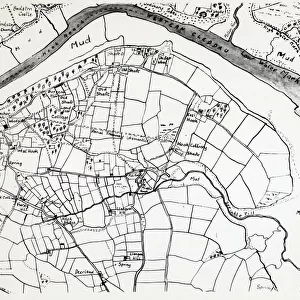
Sketch map of Hook, Pembrokeshire, South Wales

![]()
Wall Art and Photo Gifts from Mary Evans Picture Library
Sketch map of Hook, Pembrokeshire, South Wales
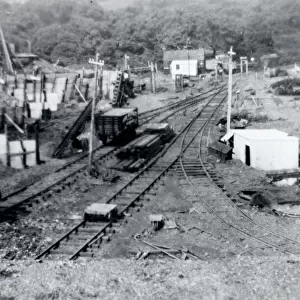
A sketch map of the village of Hook, including the various mining shafts of the colliery, on the Western Cleddau near Haverfordwest, Pembrokeshire, South Wales. The map was drawn by the manager of the mine. Date: 1930
Mary Evans Picture Library makes available wonderful images created for people to enjoy over the centuries
Media ID 4474301
© Mary Evans Picture Library 2015 - https://copyrighthub.org/s0/hub1/creation/maryevans/MaryEvansPictureID/10428805
Anchor Cleddau Coal Coal Mine Colliery Cottage Fields Haverfordwest Hook Manager Maps Mine Mines Mining Pembrokeshire Shaft Shafts
FEATURES IN THESE COLLECTIONS
> Europe
> United Kingdom
> Wales
> Castles
> Europe
> United Kingdom
> Wales
> Maps
> Europe
> United Kingdom
> Wales
> Pembrokeshire
> Haverfordwest
> Europe
> United Kingdom
> Wales
> Rivers
> Maps and Charts
> Early Maps
> Maps and Charts
> Wales
EDITORS COMMENTS
1. Title: A Glimpse into the Past: A Sketch Map of the Historic Welsh Village of Hook, Pembrokeshire, 1930 2. Nestled in the picturesque landscape of South Wales, the quaint village of Hook, Pembrokeshire, is steeped in history and industry. This intriguing sketch map, drawn by the local colliery manager in 1930, offers a unique and captivating glimpse into the village's past. 3. The map reveals the layout of Hook, with its charming cottages, the ancient church, and the imposing castle ruins nestled along the banks of the Western Cleddau River. The village's rich history is further emphasized by the presence of an anchor symbol, a nod to its maritime past. 4. The heart of Hook's history lies in its coal mining industry, as evidenced by the numerous mining shafts of the colliery scattered throughout the map. The manager's meticulous drawing highlights the various shafts, providing a testament to the village's reliance on coal mining during the 1930s. 5. The map also showcases the village's essential establishments, such as the local inn and the fields that provided sustenance for the community. The muddy, uneven terrain surrounding the mines and the winding river Cleddau add to the authenticity of the map, transporting us back in time. 6. This sketch map offers a fascinating insight into the daily life of Hook, Pembrokeshire, during the 1930s. It serves as a reminder of the village's rich history, its resilient community, and the industrious spirit that once thrived in this beautiful corner of South Wales.
MADE IN THE UK
Safe Shipping with 30 Day Money Back Guarantee
FREE PERSONALISATION*
We are proud to offer a range of customisation features including Personalised Captions, Color Filters and Picture Zoom Tools
SECURE PAYMENTS
We happily accept a wide range of payment options so you can pay for the things you need in the way that is most convenient for you
* Options may vary by product and licensing agreement. Zoomed Pictures can be adjusted in the Basket.