Home > Europe > Italy > Sicily > Messina
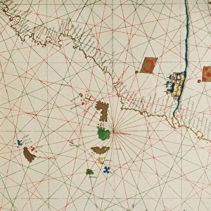
Portolan atlas by Joan Martines (1556-1590). West Coast
. West Coast")
![]()
Wall Art and Photo Gifts from Mary Evans Picture Library
Portolan atlas by Joan Martines (1556-1590). West Coast
Portolan atlas of the world by Joan Martines (1556-1590). West Coast of the African Continent. Messina, 1587. National Library. Madrid. Spain
Mary Evans Picture Library makes available wonderful images created for people to enjoy over the centuries
Media ID 14406610
© Thaliastock / Mary Evans
1587 Area Atlantic Atlas Biblioteca Cartography Chart Colours Continent Element Geography Illuminated Joan Nacional Cartographical Cosmographer
FEATURES IN THESE COLLECTIONS
> Europe
> Italy
> Sicily
> Messina
> Maps and Charts
> Related Images
EDITORS COMMENTS
This stunning image is a captivating excerpt from the Portolan atlas, a seminal work in the history of cartography created by the Catalan cartographer Joan Martines between 1556 and 1590. The specific map depicted here focuses on the West Coast of the African continent, as it appeared in the 1587 edition of the atlas, which was produced in Messina, Sicily. The Portolan atlas is renowned for its innovative use of the portolan chart, a type of nautical chart that employed rhumb lines to facilitate navigation along constant courses. This particular map showcases the intricate detail and decorative elements that were characteristic of the atlas, with the West African coastline rendered in vibrant, coloured hues. The map is adorned with various decorative elements, including an ornate cartouche at the bottom left corner, which bears the inscription "Africa," and a coat of arms at the top right corner. The flags of several European powers are depicted along the coast, indicating their presence and influence in the region during that time. The Portolan atlas was an essential tool for navigators and explorers during the Age of Discovery, as it provided accurate and detailed information about the world's coastlines, making long-distance voyages possible. This map, in particular, offers a fascinating glimpse into the geographical knowledge of the late 16th century, as well as the cosmographic and cartographical traditions of the time. This image is part of the extensive collection of the National Library in Madrid, Spain, and serves as a testament to the enduring importance of cartography in understanding the world and its rich history.
MADE IN THE UK
Safe Shipping with 30 Day Money Back Guarantee
FREE PERSONALISATION*
We are proud to offer a range of customisation features including Personalised Captions, Color Filters and Picture Zoom Tools
SECURE PAYMENTS
We happily accept a wide range of payment options so you can pay for the things you need in the way that is most convenient for you
* Options may vary by product and licensing agreement. Zoomed Pictures can be adjusted in the Basket.