
Slovakia Collection
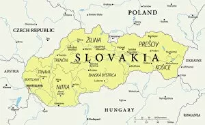
Slovakia is a landlocked country located in Central Europe, bordered by Poland to the north, Ukraine to the east
Choose a picture from our Slovakia Collection for your Wall Art and Photo Gifts
18 items


All Professionally Made to Order for Quick Shipping
-
Slovakia Collection
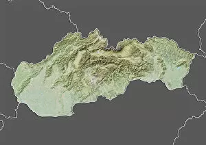
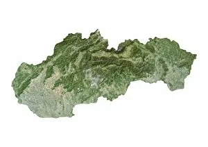
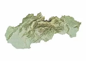
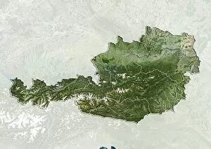
Slovakia is a landlocked country located in Central Europe, bordered by Poland to the north, Ukraine to the east, Hungary to the south and Austria and Czech Republic to the west. The country has a population of approximately 5.5 million people with its capital city being Bratislava. Slovakia's economy is heavily reliant on exports, particularly in automotive manufacturing and electronics industries. The country boasts several natural landmarks including High Tatras mountain range which attracts tourists for skiing and hiking activities. Additionally, a rich cultural heritage with numerous castles and historic towns such as Banska Stiavnica that are popular tourist destinations.
+
Our beautiful pictures are available as Framed Prints, Photos, Wall Art and Photo Gifts
The Slovakia collection from Media Storehouse offers a wide range of wall art and framed prints that showcase the beauty and diversity of this European country. Our collection features various maps, charts, and illustrations that provide detailed information about the geography, history, culture, and economy of Slovakia. From vintage maps to modern satellite images, our collection includes a variety of styles and formats to suit different tastes and preferences. Some of the most popular items in our collection include panoramic views of Bratislava Castle, colorful illustrations of traditional Slovak costumes, detailed topographic maps of national parks such as Tatra Mountains or Slovensky Raj. Whether you are looking for a unique gift for someone who loves travel or want to decorate your home with stunning artwork inspired by Slovakia's rich heritage, our collection has something for everyone. With high-quality printing techniques on premium paper stock materials used in all products offered by Media Storehouse - it is sure to impress anyone who sees it.
+
What are Slovakia (Maps and Charts) art prints?
Slovakia art prints are high-quality reproductions of maps and charts featuring the geography, topography, and landmarks of Slovakia. These prints showcase the beauty and complexity of this central European country in stunning detail, making them perfect for anyone who loves travel or has a connection to Slovakia. The maps and charts featured in these prints range from historical depictions to modern interpretations, providing a diverse selection that can suit any taste or decor style. They are printed on premium paper using advanced printing techniques to ensure vibrant colors, sharp details, and long-lasting durability. Whether you're looking for a unique piece of wall art for your home or office or seeking a thoughtful gift for someone special, Slovakia art prints offer an excellent choice. With their combination of educational value and aesthetic appeal, they make great conversation starters as well as beautiful decorations.
+
What Slovakia (Maps and Charts) art prints can I buy from Media Storehouse?
We offer a wide range of Slovakia Maps and Charts art prints that are perfect for decorating your home, office or any other space. You can choose from a variety of styles and designs that showcase the beauty and history of Slovakia. Some popular options include vintage maps of Slovakia, detailed topographical maps, colorful illustrated charts depicting the country's flora and fauna, as well as artistic renditions of famous landmarks like Bratislava Castle or High Tatras mountain range. Whether you're looking to add some character to your living room or want to create an inspiring workspace, we have something for everyone. Their high-quality prints are produced using state-of-the-art printing technology on premium paper stock ensuring vibrant colors and crisp detail in every print. So why not explore our collection today?
+
How do I buy Slovakia (Maps and Charts) art prints?
To buy Slovakia art prints from Media Storehouse, you can browse our extensive collection of artwork online. Once you have found the print that you like, simply add it to your cart and proceed to checkout. You will be prompted to enter your shipping information and payment details before completing your purchase. We offer a range of different sizes for their art prints, so make sure to select the size that best suits your needs. We also offer a variety of framing options if you would like to have your print framed before delivery. If you have any questions or concerns about purchasing Slovakia art prints from Media Storehouse, they have a dedicated customer service team who are available to assist you with any queries that you may have. With high-quality printing technology and excellent customer service, buying art prints from Media Storehouse is an easy and enjoyable experience.
+
How much do Slovakia (Maps and Charts) art prints cost?
We offer a wide selection of Slovakia maps and charts art prints that vary in price depending on the size and type of print chosen. Our collection includes vintage maps, topographical charts, and modern designs featuring the country's landmarks and cities. You can choose from various sizes ranging from small to large formats to suit their preferences. Our Slovakia maps and charts art prints are printed using high-quality materials to ensure durability and longevity. We use state-of-the-art printing technology to produce vibrant colors that accurately depict the beauty of this Central European country. Whether you're looking for a unique piece of wall decor or a thoughtful gift for someone who loves geography or travel, our Slovakia maps and charts art prints are an excellent choice. With so many options available at different price points, there is something for everyone at Media Storehouse.
+
How will my Slovakia (Maps and Charts) art prints be delivered to me?
We take pride in delivering your Slovakia art prints to you with utmost care. We use high-quality packaging materials to ensure that your print arrives in perfect condition. Our standard delivery method is through a trusted courier service, which allows us to track the progress of your order from dispatch until it reaches your doorstep. For smaller sized prints, we use sturdy cardboard envelopes or tubes depending on the size of the print. Larger prints are rolled carefully and placed inside a protective tube for safe transportation. Rest assured that all our deliveries are insured against loss or damage during transit. Once dispatched, you will receive an email notification containing tracking information so you can monitor the status of your order at any time. Westrive to provide excellent customer service and make sure that every aspect of your purchase experience is hassle-free and enjoyable.