Home > Europe > France > Canton > Bas Rhin
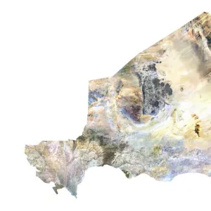
Slovakia, Relief Map

![]()
Wall Art and Photo Gifts from Universal Images Group (UIG)
Slovakia, Relief Map
Relief map of Slovakia. This map was processed from elevation data
Universal Images Group (UIG) manages distribution for many leading specialist agencies worldwide
Media ID 9618039
© Planet Observer
Alsace Bas Rhin Geographical Border Relief Map Satellite View
FEATURES IN THESE COLLECTIONS
> Aerial Photography
> Slovakia
> Europe
> France
> Canton
> Bas Rhin
> Europe
> France
> Canton
> Rhin
> Universal Images Group (UIG)
> Universal Images Group
> Satellite and Aerial
> Planet Observer 6
EDITORS COMMENTS
This print showcases the stunning relief map of Slovakia, a country nestled in the heart of Europe. The intricate details and vibrant colors bring this topographic masterpiece to life, revealing the diverse landscape that defines this enchanting nation. Processed from elevation data, every contour and ridge is meticulously portrayed, offering a unique perspective on Slovakia's physical geography. The satellite view captured by Universal Images Group (UIG) allows us to appreciate the geographical borders and boundaries that shape Slovakia's landmass. From towering mountain ranges to rolling hills and expansive plains, this relief map highlights the remarkable diversity found within its borders. As we gaze upon this awe-inspiring image, our eyes are drawn to the absence of human presence. This untouched depiction invites us to immerse ourselves in nature's beauty and contemplate the vastness of our planet. The photograph captures an outdoor scene where tranquility reigns supreme. Whether you are an avid cartography enthusiast or simply intrigued by European landscapes, this print offers a visual feast for all who admire artistry combined with scientific precision. It serves as a reminder of how interconnected our world truly is – each contour representing centuries of geological processes shaping our Earth
MADE IN THE UK
Safe Shipping with 30 Day Money Back Guarantee
FREE PERSONALISATION*
We are proud to offer a range of customisation features including Personalised Captions, Color Filters and Picture Zoom Tools
SECURE PAYMENTS
We happily accept a wide range of payment options so you can pay for the things you need in the way that is most convenient for you
* Options may vary by product and licensing agreement. Zoomed Pictures can be adjusted in the Basket.