Home > Europe > United Kingdom > England > Herefordshire > Maps
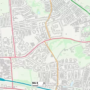
Salford M6 7 Map

![]()
Wall Art and Photo Gifts from Map Marketing
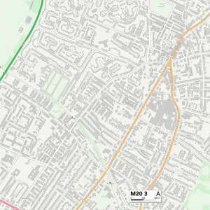
Salford M6 7 Map
Postcode Sector Map of Salford M6 7
Media ID 19974384
Alresford Road Arbour Close Ashbourne Road Avondale Drive Bank Lane Beech Avenue Beech Grove Birch Avenue Bolton Road Branksome Drive Brindle Close Broad Street Burnside Avenue Caldy Road Carlton Road Central Avenue Charles Street Churchfield Road Claremont Road Cotswold Drive Crosby Road Delamere Avenue Duchy Road Duffield Road Eastfield Enville Road Fairfield Street Godfrey Road Greenbank Road Harvest Close Helena Street Hereford Road Kendal Road King Street Linden Avenue Longmead Road Longton Road Maple Close Moorfield Road Norbury Avenue Nursery Street Oakwood Drive Oxford Road Park Lane Peacock Avenue Queen Street Salford Sandy Grove Stanhope Road Sumner Road Sunningdale Drive Tenby Drive West Drive Westfield Winton Road Woodfield Road
FEATURES IN THESE COLLECTIONS
> Animals
> Fishes
> P
> Pomfret
> Animals
> Mammals
> Muridae
> Heath Mouse
> Arts
> Artists
> C
> King Charles
> Arts
> Artists
> G
> Charles Green
> Arts
> Artists
> H
> Charles Hunt
> Arts
> Portraits
> Pop art gallery
> Street art portraits
> Europe
> United Kingdom
> England
> Herefordshire
> Maps
> Europe
> United Kingdom
> Scotland
> Aberdeenshire
> Huntly
> Europe
> United Kingdom
> Wales
> Pembrokeshire
> Tenby
> Map Marketing
> Postcode Sector Maps
> M - Manchester
> Maps and Charts
> Related Images
MADE IN THE UK
Safe Shipping with 30 Day Money Back Guarantee
FREE PERSONALISATION*
We are proud to offer a range of customisation features including Personalised Captions, Color Filters and Picture Zoom Tools
SECURE PAYMENTS
We happily accept a wide range of payment options so you can pay for the things you need in the way that is most convenient for you
* Options may vary by product and licensing agreement. Zoomed Pictures can be adjusted in the Basket.