Home > Europe > Republic of Ireland > Maps
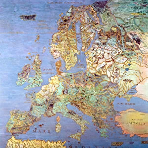
Map of Great Britain and Ireland, 1899

![]()
Wall Art and Photo Gifts from Liszt Collection
Map of Great Britain and Ireland, 1899
Liszt Collection of nineteenth-century engravings and images to browse and enjoy
Media ID 12974363
© Quint Lox Limited
1899 Great Britain Ireland Plan Chart
FEATURES IN THESE COLLECTIONS
> Europe
> Republic of Ireland
> Maps
> Liszt Collection
> Engravings
EDITORS COMMENTS
This print showcases a remarkable piece of history, the "Map of Great Britain and Ireland, 1899". Transporting us back to the enchanting nineteenth century, this intricately engraved image offers a glimpse into the past with its illustrative technique and Victorian charm. The artist's attention to detail is evident in every line and curve, capturing the essence of these two magnificent islands. The map itself serves as both a plan and chart, guiding explorers through the vast landscapes of Great Britain and Ireland. It not only highlights their geographical features but also provides insight into their rich cultural heritage. This vintage masterpiece exudes an air of nostalgia with its retro-styled aesthetics that effortlessly blend artistry and functionality. As we admire this exquisite engravement from the Liszt Collection, we are reminded of how maps have always been essential tools for understanding our world. They serve as windows into different eras, offering glimpses into bygone times while simultaneously connecting us to our roots. This particular map invites us on a journey through time, allowing us to appreciate the craftsmanship involved in creating such historical artifacts. Whether you're an avid collector or simply captivated by history's allure, this print is sure to be a cherished addition to any space. Its timeless appeal transcends generations, making it an ideal conversation starter that sparks curiosity about our shared past.
MADE IN THE UK
Safe Shipping with 30 Day Money Back Guarantee
FREE PERSONALISATION*
We are proud to offer a range of customisation features including Personalised Captions, Color Filters and Picture Zoom Tools
SECURE PAYMENTS
We happily accept a wide range of payment options so you can pay for the things you need in the way that is most convenient for you
* Options may vary by product and licensing agreement. Zoomed Pictures can be adjusted in the Basket.