Jigsaw Puzzle > Science > Space Exploration > Satellite Imagery
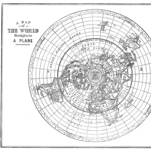
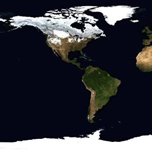
Jigsaw Puzzle : World Flat projection map from composite of satellite images. Credit NASA: Science


![]()
Jigsaw Puzzles from Universal Images Group (UIG)
World Flat projection map from composite of satellite images. Credit NASA: Science
World Flat projection map from composite of satellite images. Credit NASA: Science Earth Geology Oceanography
Universal Images Group (UIG) manages distribution for many leading specialist agencies worldwide
Media ID 9758679
© Universal History Archive/Universal Images Group
Astronomy Composite Flat Geology Meteorology Nasa Oceanography Projection Satellite Science Weather
Jigsaw Puzzle (400 Pieces)
Discover the wonders of our planet with Media Storehouse's NASA-inspired jigsaw puzzles. This captivating puzzle features a World Flat projection map derived from composite satellite images, credited to NASA: Science. Immerse yourself in the intricacies of Earth's geology, oceanography, and geography as you piece together this stunning representation of our home planet. Engage your mind and ignite your sense of adventure with Media Storehouse's educational and visually stunning puzzles.
400 piece puzzles are custom made in the UK and hand-finished on 100% recycled 1.5 mm millboard. There is a level of repetition in jigsaw shapes with each matching piece away from its pair. The completed puzzle measures 31x47cm and is delivered packaged in an attractive presentation box specially designed to fit most letter box slots
Jigsaw Puzzles are an ideal gift for any occasion
Estimated Product Size is 47.2cm x 31.5cm (18.6" x 12.4")
These are individually made so all sizes are approximate
Artwork printed orientated as per the preview above, with landscape (horizontal) or portrait (vertical) orientation to match the source image.
FEATURES IN THESE COLLECTIONS
> Maps and Charts
> Flat Earth
> Maps and Charts
> Geological Map
> Maps and Charts
> Related Images
> Maps and Charts
> World
> Science
> Space Exploration
> Related Images
> Science
> Space Exploration
> Satellite Imagery
> Universal Images Group (UIG)
> History
> Science
EDITORS COMMENTS
This print showcases a mesmerizing World Flat projection map, meticulously crafted from a composite of satellite images. With credit to the esteemed NASA: Science Earth Geology Oceanography division, this stunning visual masterpiece offers an awe-inspiring glimpse into our planet's intricate details and breathtaking beauty. As we delve into this extraordinary image, we are transported on a virtual journey across continents and oceans. The carefully selected satellite images seamlessly blend together, revealing the diverse landscapes that adorn our world. From majestic mountain ranges to sprawling deserts, lush rainforests to vast plains, every corner of Earth is unveiled in remarkable clarity. The significance of this map extends beyond its aesthetic appeal; it serves as a valuable tool for scientists studying various disciplines such as geology, astronomy, meteorology, and oceanography. Each element presented holds vital information about our planet's dynamic nature and ever-changing climate patterns. Credit must be given to Universal Images Group (UIG) for capturing this exceptional moment in time. Their dedication to preserving scientific wonders through photography shines through in this unparalleled piece of art. Whether you are an avid explorer or simply appreciate the marvels of our world from afar, let your imagination soar with this incredible World Flat projection map. It reminds us all that despite our differences and distances apart, we share one home—a fragile blue dot suspended amidst the vastness of space.
MADE IN THE UK
Safe Shipping with 30 Day Money Back Guarantee
FREE PERSONALISATION*
We are proud to offer a range of customisation features including Personalised Captions, Color Filters and Picture Zoom Tools
SECURE PAYMENTS
We happily accept a wide range of payment options so you can pay for the things you need in the way that is most convenient for you
* Options may vary by product and licensing agreement. Zoomed Pictures can be adjusted in the Basket.