Jigsaw Puzzle > Europe > United Kingdom > England > Yorkshire > Sheffield
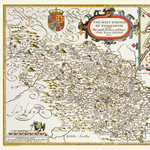
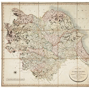
Jigsaw Puzzle : The West Riding of Yorkshire, 1701


![]()
Jigsaw Puzzles from Sheffield City Archives
The West Riding of Yorkshire, 1701
By Robert Morden.Scale 10 small miles : 1 1/8 inches.Original at Local Studies Library: E3VS
Sheffield City Archives and Local Studies Library has an unrivalled collection of images of Sheffield, England
Media ID 14047388
© Sheffield City Council
Jigsaw Puzzle (500 Pieces)
Discover the rich history of Yorkshire with our captivating jigsaw puzzle from Media Storehouse. Featuring an intricately detailed image of "The West Riding of Yorkshire, 1701" from Sheffield City Archives, this puzzle brings the past to life. Originally mapped by Robert Morden, this historical map is a must-have for history enthusiasts and puzzle lovers alike. Immerse yourself in the intricacies of this 10 small miles scale puzzle and unearth the stories hidden within its borders. Bring history into your home and enjoy the satisfaction of piecing together this fascinating piece of the past.
500 piece puzzles are custom made in the UK and hand-finished on 100% recycled 1.5 mm millboard. There is a level of repetition in jigsaw shapes with each matching piece away from its pair. The completed puzzle measures 38x50cm and is delivered packaged in an attractive presentation box specially designed to fit most letter box slots
Jigsaw Puzzles are an ideal gift for any occasion
Estimated Product Size is 50.2cm x 38cm (19.8" x 15")
These are individually made so all sizes are approximate
Artwork printed orientated as per the preview above, with landscape (horizontal) or portrait (vertical) orientation to match the source image.
FEATURES IN THESE COLLECTIONS
> Europe
> United Kingdom
> England
> West Yorkshire
> Related Images
> Europe
> United Kingdom
> England
> Yorkshire
> Related Images
> Europe
> United Kingdom
> England
> Yorkshire
> Sheffield
> Maps and Charts
> Related Images
> Sheffield City Archives
> Maps and Plans
EDITORS COMMENTS
This print showcases "The West Riding of Yorkshire, 1701" map by Robert Morden, a renowned cartographer of his time. The intricate details and precision in this piece offer a glimpse into the historical landscape of Yorkshire over three centuries ago. With a scale of 10 small miles to 1 1/8 inches, this map provides an accurate representation of the region's topography and settlements during that era. From sprawling hills to meandering rivers, every contour is meticulously depicted, allowing viewers to immerse themselves in the beauty and diversity of the West Riding. Preserved at Sheffield City Archives' Local Studies Library under reference E3VS, this original artifact holds immense value for historians and geography enthusiasts alike. Its presence serves as a testament to the importance placed on documenting geographical knowledge even centuries ago. As we gaze upon this print today, we are transported back in time; our imagination wanders through bustling market towns like Leeds and Wakefield or explores tranquil villages nestled amidst lush greenery. This visual treasure invites us to reflect on how much has changed while appreciating the enduring essence that defines Yorkshire's charm
MADE IN THE UK
Safe Shipping with 30 Day Money Back Guarantee
FREE PERSONALISATION*
We are proud to offer a range of customisation features including Personalised Captions, Color Filters and Picture Zoom Tools
SECURE PAYMENTS
We happily accept a wide range of payment options so you can pay for the things you need in the way that is most convenient for you
* Options may vary by product and licensing agreement. Zoomed Pictures can be adjusted in the Basket.