Jigsaw Puzzle > Arts > Contemporary art > Landscapes > Street art
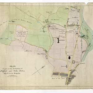
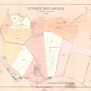
Jigsaw Puzzle : Street map of Nether Hallam


![]()
Jigsaw Puzzles from Sheffield City Archives
Street map of Nether Hallam
Undated but before 1897 as it shows Hillsborough Hall and grounds which were acquired by the City Council in that year and the grounds opened as Hillsborough Park. The Hall was opened as Hillsborough Library in 1905.Original at Local Studies S37S
Sheffield City Archives and Local Studies Library has an unrivalled collection of images of Sheffield, England
Media ID 14048984
© Sheffield City Council
Bridge Crookes Features Gardens Hall Hill Hillsborough Hospitals Joseph Malin Maps Owlerton Park Parks Royal Sheffield Barracks Bole Dykes Howard Infirmary Quarries Shirecliffe Weston
Jigsaw Puzzle (400 Pieces)
Discover the rich history of Sheffield with our Media Storehouse Jigsaw Puzzle featuring a captivating street map of Nether Hallam from the Sheffield City Archives. This intricately detailed puzzle showcases the layout of the area as it appeared before 1897, featuring Hillsborough Hall and its stunning grounds which were later acquired by the City Council and opened as Hillsborough Park. Immerse yourself in the past as you piece together this 500-piece puzzle, a perfect activity for puzzle enthusiasts, history buffs, and families. Get ready to explore and learn as you uncover the stories hidden within the streets of Nether Hallam.
400 piece puzzles are custom made in the UK and hand-finished on 100% recycled 1.5 mm millboard. There is a level of repetition in jigsaw shapes with each matching piece away from its pair. The completed puzzle measures 31x47cm and is delivered packaged in an attractive presentation box specially designed to fit most letter box slots
Jigsaw Puzzles are an ideal gift for any occasion
Estimated Product Size is 47.2cm x 31.5cm (18.6" x 12.4")
These are individually made so all sizes are approximate
Artwork printed orientated as per the preview above, with landscape (horizontal) or portrait (vertical) orientation to match the source image.
FEATURES IN THESE COLLECTIONS
> Arts
> Contemporary art
> Landscapes
> Street art
> Maps and Charts
> Related Images
> Sheffield City Archives
> Maps and Plans
EDITORS COMMENTS
This print showcases a street map of Nether Hallam, an area in Sheffield that has undergone significant transformations over the years. Undated but believed to be before 1897, this map provides a glimpse into the past by including notable landmarks such as Hillsborough Hall and its grounds. It is worth noting that these grounds were acquired by the City Council in 1897 and subsequently opened as Hillsborough Park, while the hall itself was repurposed as Hillsborough Library in 1905. The intricate details on this map reveal various other points of interest within Nether Hallam and its surrounding areas. From Crookes to Owlerton, Dykes to Barracks, Shirecliffe to Parks and Gardens, Malin Bridge to Weston – each location adds depth to the historical landscape depicted here. Additionally, it highlights important institutions like Royal Infirmary Hospitals and Quarries. Notably featured are Bole Hill and Howard Street alongside St. Joseph Home for Catholic Girls - all contributing their unique character to Nether Hallam's rich history. Preserved at Sheffield City Archives under reference S37S, this original print serves as a valuable resource for researchers delving into Sheffield's past. Its detailed depiction invites us on a journey through time, allowing us to explore how landscapes have evolved while uncovering hidden stories embedded within these streetscapes.
MADE IN THE UK
Safe Shipping with 30 Day Money Back Guarantee
FREE PERSONALISATION*
We are proud to offer a range of customisation features including Personalised Captions, Color Filters and Picture Zoom Tools
SECURE PAYMENTS
We happily accept a wide range of payment options so you can pay for the things you need in the way that is most convenient for you
* Options may vary by product and licensing agreement. Zoomed Pictures can be adjusted in the Basket.