Jigsaw Puzzle > Europe > Republic of Ireland > Maps
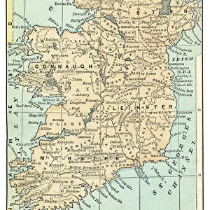
Jigsaw Puzzle : Ireland in the 16th century


![]()
Jigsaw Puzzles from North Wind
Ireland in the 16th century
Map of Ireland before the English invasion, circa 1580.
Color lithograph reproduction of a 19th-century illustration
North Wind Picture Archives brings history to life with stock images and hand-colored illustrations
Media ID 5879048
© North Wind Picture Archives
1500s 16th Century British Isles Celt Celtic Eire Europe European Ireland Irish Medieval Middle Ages
Jigsaw Puzzle (400 Pieces)
Discover the rich history of Ireland with our exquisite Jigsaw Puzzle from Media Storehouse, featuring a captivating image of Ireland in the 16th century. This intriguing puzzle, sourced from North Wind Picture Archives, showcases a detailed map of the Emerald Isle as it appeared before the English invasion, circa 1580. With a colorful lithograph reproduction of a 19th-century illustration, this puzzle offers an engaging and educational experience for puzzle enthusiasts of all ages. Immerse yourself in the history and culture of Ireland as you piece together this stunning jigsaw puzzle, making it a perfect addition to any home or classroom.
400 piece puzzles are custom made in the UK and hand-finished on 100% recycled 1.5 mm millboard. There is a level of repetition in jigsaw shapes with each matching piece away from its pair. The completed puzzle measures 31x47cm and is delivered packaged in an attractive presentation box specially designed to fit most letter box slots
Jigsaw Puzzles are an ideal gift for any occasion
Estimated Product Size is 31.5cm x 47.2cm (12.4" x 18.6")
These are individually made so all sizes are approximate
Artwork printed orientated as per the preview above, with landscape (horizontal) or portrait (vertical) orientation to match the source image.
FEATURES IN THESE COLLECTIONS
> Arts
> Art Movements
> Medieval Art
> Europe
> Republic of Ireland
> Maps
> Maps and Charts
> Related Images
> North Wind Picture Archives
> British history
> North Wind Picture Archives
> Maps
EDITORS COMMENTS
This print takes us back in time to Ireland during the 16th century, offering a glimpse into its rich and storied past. The map depicted here showcases Ireland before the English invasion, circa 1580. A color lithograph reproduction of a 19th-century illustration, it beautifully captures the essence of this Celtic nation. The image transports us to an era where vibrant green landscapes dominated the countryside, dotted with ancient castles and monastic ruins that speak volumes about Ireland's heritage. This vintage artwork invites us to explore every county of this enchanting land, each one steeped in traditional customs and historic significance. As we delve deeper into the details of this medieval map, we can almost hear echoes from centuries ago when Irish culture thrived amidst turbulent times. It serves as a reminder of how Ireland stood strong against external influences while embracing its own unique identity. With its intricate illustrations and delicate craftsmanship, this artwork is not just a mere depiction but also an artistic representation of history itself. It unveils the complex tapestry woven by various European civilizations that left their mark on these shores throughout the Middle Ages. Let this mesmerizing print transport you to another time – an era when Celtic traditions flourished and Irish pride ran deep within these emerald isles. Immerse yourself in the beauty and allure of ancient Eire through this remarkable piece of artistry that celebrates both Ireland's past and present.
MADE IN THE UK
Safe Shipping with 30 Day Money Back Guarantee
FREE PERSONALISATION*
We are proud to offer a range of customisation features including Personalised Captions, Color Filters and Picture Zoom Tools
SECURE PAYMENTS
We happily accept a wide range of payment options so you can pay for the things you need in the way that is most convenient for you
* Options may vary by product and licensing agreement. Zoomed Pictures can be adjusted in the Basket.