Jigsaw Puzzle > Maps and Charts > Americas
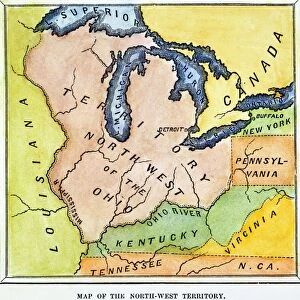
Jigsaw Puzzle : Northwest Territory map


![]()
Jigsaw Puzzles from North Wind
Northwest Territory map
Map of the old Northwest Territory, 1787.
Printed color lithograph of a 19th-century illustration
North Wind Picture Archives brings history to life with stock images and hand-colored illustrations
Media ID 5877426
© North Wind Picture Archives
1700s 1787 18th Century America Border Boundary East Eastern Northwest Territory Old Northwest States Territory
Jigsaw Puzzle (400 Pieces)
Discover the rich history of North America with our captivating Northwest Territory map jigsaw puzzle from Media Storehouse. This intricately detailed puzzle, featuring a vintage 19th-century illustration from North Wind Picture Archives, is an engaging and educational activity for all ages. Assemble the colorful pieces to reveal the intricacies of the old Northwest Territory map from 1787. A perfect addition to your home or classroom, this puzzle is not only a fun challenge but also a beautiful display piece. Immerse yourself in history and create lasting memories with the Northwest Territory map puzzle from Media Storehouse.
400 piece puzzles are custom made in the UK and hand-finished on 100% recycled 1.5 mm millboard. There is a level of repetition in jigsaw shapes with each matching piece away from its pair. The completed puzzle measures 31x47cm and is delivered packaged in an attractive presentation box specially designed to fit most letter box slots
Jigsaw Puzzles are an ideal gift for any occasion
Estimated Product Size is 31.5cm x 47.2cm (12.4" x 18.6")
These are individually made so all sizes are approximate
Artwork printed orientated as per the preview above, with landscape (horizontal) or portrait (vertical) orientation to match the source image.
FEATURES IN THESE COLLECTIONS
> Maps and Charts
> Related Images
> North America
> Related Images
> North Wind Picture Archives
> American history
> North Wind Picture Archives
> Maps
EDITORS COMMENTS
This vintage print showcases a meticulously detailed map of the old Northwest Territory from 1787. The map, presented in stunning printed color lithograph, transports us back to the 18th century when America was still shaping its identity. With its intricate borders and traditional illustrations, this piece is a true testament to our rich heritage. The map depicts the eastern region of North America, specifically highlighting the boundary lines and territories that comprised the Northwest Territory during this pivotal time in history. It serves as a visual representation of the thirteen original states that formed the United States at that period. As we gaze upon this artful creation, we can't help but marvel at how it encapsulates both beauty and historical significance. Its vibrant colors breathe life into each state's distinct boundaries while providing an educational glimpse into early American history. Whether you are an avid collector or simply appreciate fine art with cultural value, this print is sure to be a cherished addition to any space. Let it transport you back in time as you explore and admire every intricacy within its borders – a tangible reminder of our nation's past and an homage to those who shaped it.
MADE IN THE UK
Safe Shipping with 30 Day Money Back Guarantee
FREE PERSONALISATION*
We are proud to offer a range of customisation features including Personalised Captions, Color Filters and Picture Zoom Tools
SECURE PAYMENTS
We happily accept a wide range of payment options so you can pay for the things you need in the way that is most convenient for you
* Options may vary by product and licensing agreement. Zoomed Pictures can be adjusted in the Basket.