Jigsaw Puzzle > Europe > Croatia > Maps
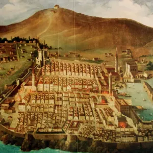
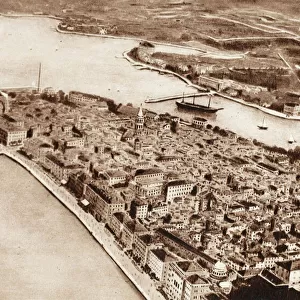
Jigsaw Puzzle : Dubrovnik. Map of the city before the earthquake of 1667


![]()
Jigsaw Puzzles from Mary Evans Picture Library
Dubrovnik. Map of the city before the earthquake of 1667
Dubrovnik. Map of the city before the earthquake of 1667. Croatia
Mary Evans Picture Library makes available wonderful images created for people to enjoy over the centuries
Media ID 14340468
© Thaliastock / Mary Evans
Adriatic Cartography Contour Croatia Croatian Dalmatian Dubrovnik Mapping Pearl Perimeter Seventeenth Walled Xvii Xviith
Jigsaw Puzzle (400 Pieces)
Discover the rich history of Dubrovnik with our captivating jigsaw puzzle from Media Storehouse. This intricately detailed puzzle features an ancient map of the city as it appeared before the devastating earthquake of 1667. With rights managed from Mary Evans Prints Online, this puzzle showcases the Croatian gem's historic layout, complete with winding streets, fortifications, and the Adriatic Sea. Immerse yourself in the past as you piece together this beautiful and educational puzzle, perfect for history enthusiasts and puzzle lovers alike.
400 piece puzzles are custom made in the UK and hand-finished on 100% recycled 1.5 mm millboard. There is a level of repetition in jigsaw shapes with each matching piece away from its pair. The completed puzzle measures 31x47cm and is delivered packaged in an attractive presentation box specially designed to fit most letter box slots
Jigsaw Puzzles are an ideal gift for any occasion
Estimated Product Size is 47.2cm x 31.5cm (18.6" x 12.4")
These are individually made so all sizes are approximate
Artwork printed orientated as per the preview above, with landscape (horizontal) or portrait (vertical) orientation to match the source image.
FEATURES IN THESE COLLECTIONS
> Europe
> Croatia
> Related Images
> Maps and Charts
> Early Maps
> Maps and Charts
> Related Images
EDITORS COMMENTS
This print showcases a historic map of Dubrovnik before the devastating earthquake of 1667. The intricate details and precision of the cartography highlight the city's layout along the stunning Adriatic coast. This 17th-century map provides a glimpse into Dubrovnik's past, showcasing its walled perimeter, mountainous backdrop, and strategic location as a Dalmatian pearl.
The map serves as a window into history, offering insight into Dubrovnik's rich cultural heritage and architectural significance. The careful contouring of the city walls and streets reflects the meticulous craftsmanship of early modern mapping techniques.
Dubrovnik, often referred to as the "Pearl of the Adriatic," has long been admired for its beauty and resilience in the face of natural disasters such as earthquakes. This image captures a moment frozen in time before tragedy struck, preserving the city's historical footprint for future generations to appreciate.
As we gaze upon this piece of Croatian history, we are reminded of Dubrovnik's enduring spirit and timeless allure. It stands as a testament to human ingenuity and perseverance in the face of adversity, making it not just a map but a symbol of strength and resilience.
MADE IN THE UK
Safe Shipping with 30 Day Money Back Guarantee
FREE PERSONALISATION*
We are proud to offer a range of customisation features including Personalised Captions, Color Filters and Picture Zoom Tools
SECURE PAYMENTS
We happily accept a wide range of payment options so you can pay for the things you need in the way that is most convenient for you
* Options may vary by product and licensing agreement. Zoomed Pictures can be adjusted in the Basket.