Jigsaw Puzzle > Europe > United Kingdom > England > London > Towns > Welling
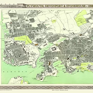
Jigsaw Puzzle : Old Map of the Environs of Plymouth and Devonport 1836 by Thomas Moule


![]()
Jigsaw Puzzles from MapSeeker
Old Map of the Environs of Plymouth and Devonport 1836 by Thomas Moule
This is a fine decorative reproduction Map of The Environs of Plymouth and Devonport from the First Edition series of Thomas Moule Maps, originally Published in 1836. The well-known series of County Maps which are known as Moules feature beautiful vignette views, there were also 4 " Environs" Maps included, and were first published in separate sections for each county in 1830-32, they were then published in collected form in a two-volume work: The English Counties Delineated: or a Topographical Description of England: Illustrated by a Complete Series of County Maps by Thomas Moule: London: Published by George Virtue 1836
Welcome to the Mapseeker Image library and enter an historic gateway to one of the largest on-line collections of Historic Maps, Nostalgic Views, Vista's and Panorama's from a World gone by.
Media ID 20348104
© Mapseeker Publishing Ltd
Historic Map Moule Map Old Moule Map Thomas Moule Thomas Moule Map Devonport Plymouth
Jigsaw Puzzle (500 Pieces)
Discover the rich history of Plymouth and Devonport with our exquisite jigsaw puzzle from the Media Storehouse range. This intricately detailed puzzle features an old map of the environs of Plymouth and Devonport, originally published by Thomas Moule and George Virtue in 1836. The vintage map, reproduced from the First Edition series of Thomas Moule Maps by MapSeeker, invites you on a journey through time as you piece together the intricate image. Ideal for puzzle enthusiasts and history buffs alike, this challenging yet rewarding puzzle is a beautiful addition to any home or office.
500 piece puzzles are custom made in the UK and hand-finished on 100% recycled 1.5 mm millboard. There is a level of repetition in jigsaw shapes with each matching piece away from its pair. The completed puzzle measures 38x50cm and is delivered packaged in an attractive presentation box specially designed to fit most letter box slots
Jigsaw Puzzles are an ideal gift for any occasion
Estimated Product Size is 50.2cm x 38cm (19.8" x 15")
These are individually made so all sizes are approximate
Artwork printed orientated as per the preview above, with landscape (horizontal) or portrait (vertical) orientation to match the source image.
FEATURES IN THESE COLLECTIONS
> Arts
> Artists
> M
> Thomas Moule
> Europe
> United Kingdom
> England
> London
> Towns
> Welling
> Europe
> United Kingdom
> England
> Maps
> Europe
> United Kingdom
> England
> Plymouth
> Europe
> United Kingdom
> England
> Wells
> Maps and Charts
> Related Images
> MapSeeker
> British Town And City Plans
> English & Welsh PORTFOLIO
> MapSeeker
> Maps from the British Isles
> England and Counties PORTFOLIO
EDITORS COMMENTS
This exquisite print showcases the "Old Map of the Environs of Plymouth and Devonport 1836" by Thomas Moule. Originally published in 1836 as part of Moule's renowned series of County Maps, this decorative reproduction captures the beauty and historical significance of the original map. Thomas Moule's maps are known for their intricate details and stunning vignette views, which add a touch of elegance to his cartographic works. This particular map is one of four "Environs" maps included in Moule's collection, providing a comprehensive depiction of the surrounding areas of Plymouth and Devonport. Published by George Virtue in London, this two-volume work titled "The English Counties Delineated: or a Topographical Description of England" offers readers a complete series of county maps accompanied by detailed descriptions. The inclusion of these meticulously crafted maps allows readers to explore England's topography while appreciating Moule's artistic talent. As you delve into this historic map, you will be transported back to 1836 when Plymouth and Devonport were thriving maritime towns. Discovering streets, landmarks, and even long-gone structures on this old map provides an intriguing glimpse into the past. Whether you have a personal connection to these areas or simply appreciate history and cartography, this print is sure to captivate your imagination with its rich detail and nostalgic charm.
MADE IN THE UK
Safe Shipping with 30 Day Money Back Guarantee
FREE PERSONALISATION*
We are proud to offer a range of customisation features including Personalised Captions, Color Filters and Picture Zoom Tools
SECURE PAYMENTS
We happily accept a wide range of payment options so you can pay for the things you need in the way that is most convenient for you
* Options may vary by product and licensing agreement. Zoomed Pictures can be adjusted in the Basket.