Jigsaw Puzzle > Arts > Minimalist artwork > Monochrome artwork > Fine art
Jigsaw Puzzle : Map of Ireland, c1930s


![]()
Jigsaw Puzzles from Heritage Images
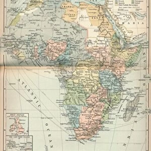
Map of Ireland, c1930s
Map of Ireland, c1930s. A print from Countries of the World, edited by JA Hammerton, volume IV, The Fleetway House, c1930s
Heritage Images features heritage image collections
Media ID 14951606
© The Print Collector / Heritage-Images
Cartography Eire Ireland Island Map Making Print Collector12
Jigsaw Puzzle (400 Pieces)
Discover the charm of the past with our vintage Map of Ireland jigsaw puzzle from Media Storehouse. This beautifully intricate puzzle features an authentic 1930s map of Ireland, taken from the pages of "Countries of the World," edited by JA Hammerton. Travel back in time and immerse yourself in the history and culture of this captivating country. With intricate details and vibrant colors, this puzzle is perfect for puzzle enthusiasts, history buffs, or anyone looking for a nostalgic and engaging activity. Bring the past to life with the Media Storehouse Map of Ireland puzzle.
400 piece puzzles are custom made in the UK and hand-finished on 100% recycled 1.5 mm millboard. There is a level of repetition in jigsaw shapes with each matching piece away from its pair. The completed puzzle measures 31x47cm and is delivered packaged in an attractive presentation box specially designed to fit most letter box slots
Jigsaw Puzzles are an ideal gift for any occasion
Estimated Product Size is 31.5cm x 47.2cm (12.4" x 18.6")
These are individually made so all sizes are approximate
Artwork printed orientated as per the preview above, with landscape (horizontal) or portrait (vertical) orientation to match the source image.
FEATURES IN THESE COLLECTIONS
> Animals
> Mammals
> Muridae
> House Mouse
> Arts
> Minimalist artwork
> Monochrome artwork
> Fine art
> Arts
> Minimalist artwork
> Monochrome artwork
> Monochrome paintings
> Europe
> Republic of Ireland
> Maps
> Maps and Charts
> Related Images
> Maps and Charts
> World
EDITORS COMMENTS
This print showcases a Map of Ireland from the 1930s, offering a glimpse into the geographical landscape of this enchanting island. The intricate cartography details every nook and cranny, providing an accurate depiction of Ireland's diverse terrain. Created by an unknown artist, this vintage print is part of the esteemed collection "Countries of the World" edited by JA Hammerton. The monochrome aesthetic adds a touch of nostalgia to this piece, transporting viewers back to a time when map-making was both an art form and a scientific endeavor. With its delicate lines and precise labeling, this map serves as a testament to the meticulous craftsmanship that went into creating such visual representations. Ireland's rich history and cultural heritage are deeply intertwined with its geography, making this print all the more intriguing. From rugged coastlines to lush green valleys, each region tells its own story within the broader narrative of Ireland's past. Whether you're fascinated by cartography or simply intrigued by Ireland's allure, this vintage print offers both beauty and educational value. It serves as a window into another era while reminding us that even in our modern world dominated by digital maps, there is still something magical about holding tangible pieces of history in our hands.
MADE IN THE UK
Safe Shipping with 30 Day Money Back Guarantee
FREE PERSONALISATION*
We are proud to offer a range of customisation features including Personalised Captions, Color Filters and Picture Zoom Tools
SECURE PAYMENTS
We happily accept a wide range of payment options so you can pay for the things you need in the way that is most convenient for you
* Options may vary by product and licensing agreement. Zoomed Pictures can be adjusted in the Basket.