Jigsaw Puzzle > Arts > Landscape paintings > Waterfall and river artworks > River artworks
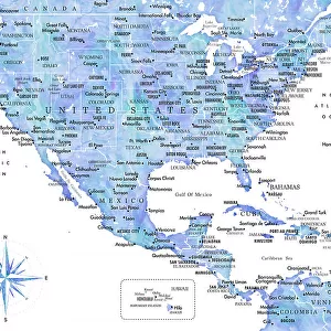
Jigsaw Puzzle : MAP: UNITED STATES, 1837. Engraved map of the United States, 1837, by T


![]()
Jigsaw Puzzles from Granger
MAP: UNITED STATES, 1837. Engraved map of the United States, 1837, by T
MAP: UNITED STATES, 1837. Engraved map of the United States, 1837, by T.G. Bradford showing the states and territories as well as the northern part of Mexico
Granger holds millions of images spanning more than 25,000 years of world history, from before the Stone Age to the dawn of the Space Age
Media ID 6617591
1837 Latin America Mesoamerica Mexico
Jigsaw Puzzle (400 Pieces)
Discover history through the captivating world of jigsaw puzzles with Media Storehouse. Our latest addition to the collection is an intriguing 1837 map of the United States, meticulously engraved by T.G. Bradford. This vintage puzzle showcases the United States as it was before the Mexican-American War, featuring the states and territories, as well as the northern part of Mexico. Delve into the past as you piece together this educational and engaging puzzle, perfect for history enthusiasts and puzzle lovers alike. Experience the thrill of completing a puzzle while learning about the evolution of the United States. Engage your mind and transport yourself back in time with Media Storehouse's historic jigsaw puzzles.
400 piece puzzles are custom made in the UK and hand-finished on 100% recycled 1.5 mm millboard. There is a level of repetition in jigsaw shapes with each matching piece away from its pair. The completed puzzle measures 31x47cm and is delivered packaged in an attractive presentation box specially designed to fit most letter box slots
Jigsaw Puzzles are an ideal gift for any occasion
Estimated Product Size is 47.2cm x 31.5cm (18.6" x 12.4")
These are individually made so all sizes are approximate
Artwork printed orientated as per the preview above, with landscape (horizontal) or portrait (vertical) orientation to match the source image.
FEATURES IN THESE COLLECTIONS
> Granger Art on Demand
> Maps
> Arts
> Landscape paintings
> Waterfall and river artworks
> River artworks
> Maps and Charts
> Early Maps
> Maps and Charts
> Related Images
> North America
> Mexico
> Maps
> North America
> Mexico
> Related Images
EDITORS COMMENTS
This print showcases an engraved map of the United States from the year 1837. Created by T. G. Bradford, this meticulously detailed piece provides a fascinating glimpse into the early history of America and its neighboring regions. The map not only displays the states and territories that existed during that time but also includes a portion of northern Mexico. The intricate lines and delicate shading on this vintage map highlight the artistry involved in cartography during this era. It serves as a testament to the skill and precision required to accurately depict geographical features such as rivers, mountains, and coastlines. Beyond its aesthetic appeal, this historical artifact offers valuable insights into how borders have evolved over time in North America. By showcasing both American territories and parts of Mexico, it sheds light on the interconnectedness between these two nations during the 19th century. Whether you are a history enthusiast or simply appreciate fine art, this print is sure to captivate your imagination. Its rich colors and intricate details make it an ideal addition to any space seeking to evoke a sense of nostalgia or curiosity about our nation's past.
MADE IN THE UK
Safe Shipping with 30 Day Money Back Guarantee
FREE PERSONALISATION*
We are proud to offer a range of customisation features including Personalised Captions, Color Filters and Picture Zoom Tools
SECURE PAYMENTS
We happily accept a wide range of payment options so you can pay for the things you need in the way that is most convenient for you
* Options may vary by product and licensing agreement. Zoomed Pictures can be adjusted in the Basket.