Jigsaw Puzzle > Fine Art Storehouse > Photo Libraries > Heritage Images
Jigsaw Puzzle : Sixteenth Century Britain


![]()
Jigsaw Puzzles from Fine Art Storehouse
Sixteenth Century Britain
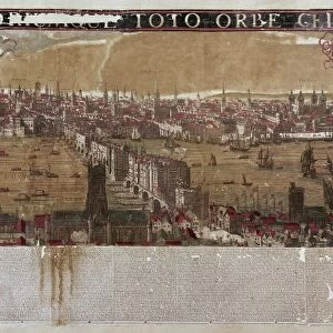
An early sixteenth century map of Great Britain, from The Cotton Library, circa 1500. (Photo by Hulton Archive/Getty Images)
Unleash your creativity and transform your space into a visual masterpiece!
Hulton Archive
Media ID 11805036
© 2005 Getty Images
15697 Britain Earlydate Scotland Wales Diry Orig
Jigsaw Puzzle (400 Pieces)
Step back in time with our captivating jigsaw puzzle from Media Storehouse, featuring an intriguing image of Sixteenth Century Britain. This exquisite puzzle, sourced from the Hulton Archive at the Fine Art Storehouse, showcases an early sixteenth century map of Great Britain from The Cotton Library. With intricate details and authentic hues, this puzzle offers a unique opportunity to explore the rich history of the British Isles during this fascinating era. Immerse yourself in the puzzle-solving experience and uncover the stories hidden within the lines and borders of this historical treasure. Puzzle pieces are made from high-quality, premium board for a satisfying fit and a beautiful finished product.
400 piece puzzles are custom made in the UK and hand-finished on 100% recycled 1.5 mm millboard. There is a level of repetition in jigsaw shapes with each matching piece away from its pair. The completed puzzle measures 31x47cm and is delivered packaged in an attractive presentation box specially designed to fit most letter box slots
Jigsaw Puzzles are an ideal gift for any occasion
Estimated Product Size is 31.5cm x 47.2cm (12.4" x 18.6")
These are individually made so all sizes are approximate
Artwork printed orientated as per the preview above, with landscape (horizontal) or portrait (vertical) orientation to match the source image.
EDITORS COMMENTS
This print takes us back in time to the sixteenth century, offering a glimpse into the rich history of Britain. The image showcases an early map of Great Britain, meticulously preserved from The Cotton Library and dating back to circa 1500. As we delve into this intricate piece of cartography, we are transported to a bygone era where exploration and discovery were at their peak. The map encompasses the entire region of Great Britain, including England, Wales, and Scotland. Its detailed depiction provides valuable insights into the geographical layout and political divisions that existed during this period. With its faded colors and delicate lines, it exudes an air of authenticity that adds to its historical significance. As we study this ancient map closely, our eyes trace the contours of rivers snaking through lush landscapes while towns and cities emerge as tiny dots representing bustling centers of activity. It is a testament to human curiosity and ingenuity as explorers ventured across uncharted territories in search of new lands or trade routes. This print serves as a window into a world long past; it invites us to appreciate the intricacies involved in mapping vast regions with limited technology available at that time. It reminds us how far we have come in understanding our planet's geography while also igniting a sense of wonder for those who paved the way for modern cartography.
MADE IN THE UK
Safe Shipping with 30 Day Money Back Guarantee
FREE PERSONALISATION*
We are proud to offer a range of customisation features including Personalised Captions, Color Filters and Picture Zoom Tools
SECURE PAYMENTS
We happily accept a wide range of payment options so you can pay for the things you need in the way that is most convenient for you
* Options may vary by product and licensing agreement. Zoomed Pictures can be adjusted in the Basket.