Jigsaw Puzzle > Europe > France > Maps
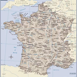
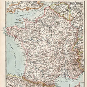
Jigsaw Puzzle : Map of France 1886


![]()
Jigsaw Puzzles from Fine Art Storehouse
Map of France 1886
Map of France Maps Monteith Physical Geography 1886
Unleash your creativity and transform your space into a visual masterpiece!
THEPALMER
Media ID 14756944
© This content is subject to copyright
Jigsaw Puzzle (400 Pieces)
Discover the rich history and geography of France with our captivating jigsaw puzzle from Media Storehouse. Featuring the intricately detailed "Map of France 1886" by THEPALMER from Fine Art Storehouse, this puzzle invites you on a journey back in time. Immerse yourself in the physical geography of France as it was represented in 1886, with meticulously rendered borders, topography, and place names. Perfect for puzzle enthusiasts, history buffs, or anyone looking to expand their knowledge of the world, this challenging and rewarding puzzle offers hours of engaging entertainment.
400 piece puzzles are custom made in the UK and hand-finished on 100% recycled 1.5 mm millboard. There is a level of repetition in jigsaw shapes with each matching piece away from its pair. The completed puzzle measures 31x47cm and is delivered packaged in an attractive presentation box specially designed to fit most letter box slots
Jigsaw Puzzles are an ideal gift for any occasion
Estimated Product Size is 47.2cm x 31.5cm (18.6" x 12.4")
These are individually made so all sizes are approximate
Artwork printed orientated as per the preview above, with landscape (horizontal) or portrait (vertical) orientation to match the source image.
FEATURES IN THESE COLLECTIONS
> Fine Art Storehouse
> Map
> Historical Maps
> Maps and Charts
> Related Images
EDITORS COMMENTS
In this print titled "Map of France 1886" we are transported back in time to the late 19th century. The map, originally published as part of the Monteith Physical Geography collection, offers a fascinating glimpse into the intricate details and artistic craftsmanship of cartography during that era. The carefully drawn lines and delicate shading bring forth a sense of nostalgia, reminding us of an age when maps were meticulously handcrafted works of art. As our eyes wander across the image, we can trace the borders and contours that define France's diverse landscapes – from its majestic mountain ranges to its meandering rivers and picturesque coastlines. This particular rendition captures France at a significant moment in history. It allows us to explore not only its geographical features but also provides insights into political boundaries and regional divisions prevalent during that period. Each city, town, and village is marked with precision, inviting us to embark on a journey through time as we imagine life in these different regions over a century ago. "The Map of France 1886" by THEPALMER serves as both an educational tool for geography enthusiasts and an exquisite piece of artwork for collectors. Its historical significance combined with its aesthetic appeal makes it a timeless addition to any space – be it your study or living room – where it can spark conversations about history, culture, or simply ignite one's imagination about exploring the beautiful country depicted within its borders.
MADE IN THE UK
Safe Shipping with 30 Day Money Back Guarantee
FREE PERSONALISATION*
We are proud to offer a range of customisation features including Personalised Captions, Color Filters and Picture Zoom Tools
SECURE PAYMENTS
We happily accept a wide range of payment options so you can pay for the things you need in the way that is most convenient for you
* Options may vary by product and licensing agreement. Zoomed Pictures can be adjusted in the Basket.