Jigsaw Puzzle > Maps and Charts > World
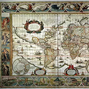
Jigsaw Puzzle : Map of the world 1800


![]()
Jigsaw Puzzles from Fine Art Storehouse
Map of the world 1800
Unleash your creativity and transform your space into a visual masterpiece!
THEPALMER
Media ID 15241435
© Roberto A Sanchez
Atlas Earth Map03 Oceania Paper Retro Revival World Map
Jigsaw Puzzle (400 Pieces)
Discover the fascinating historical details of the world in the early 1800s with our captivating "Map of the World 1800" jigsaw puzzle from THEPALMER at Media Storehouse. This intricately detailed Fine Art Storehouse puzzle brings to life the geographical landscape of the time, allowing you to explore and learn as you piece together continents, countries, and territories as they once were. Immerse yourself in history and enjoy the satisfying experience of completing this beautifully illustrated puzzle, making it an excellent addition to your collection or a thoughtful gift for history enthusiasts and puzzle lovers alike. Unleash your inner explorer and let the adventure begin!
400 piece puzzles are custom made in the UK and hand-finished on 100% recycled 1.5 mm millboard. There is a level of repetition in jigsaw shapes with each matching piece away from its pair. The completed puzzle measures 31x47cm and is delivered packaged in an attractive presentation box specially designed to fit most letter box slots
Jigsaw Puzzles are an ideal gift for any occasion
Estimated Product Size is 47.2cm x 31.5cm (18.6" x 12.4")
These are individually made so all sizes are approximate
Artwork printed orientated as per the preview above, with landscape (horizontal) or portrait (vertical) orientation to match the source image.
FEATURES IN THESE COLLECTIONS
> Fine Art Storehouse
> The Magical World of Illustration
> Palmer Illustrated Collection
> Fine Art Storehouse
> Map
> Historical Maps
> Maps and Charts
> Related Images
> Maps and Charts
> World
EDITORS COMMENTS
In this print titled "Map of the World 1800" we are transported back in time to an era when cartography was a meticulous art form. The image showcases a beautifully preserved antique world map, exuding a sense of nostalgia and wonder. The attention to detail is striking as every contour and boundary is meticulously outlined on the aged paper. This retro revival piece takes us on a journey across continents, unveiling the physical geography that shaped our planet centuries ago. From the vast oceans to the sprawling landmasses, each element tells its own story. As we explore this vintage atlas, our eyes are drawn to Oceania, with its scattered islands dotting the Pacific Ocean like precious gems. The intricate depiction of Earth's seas invites us to imagine brave explorers sailing uncharted waters in search of new lands and adventures. "The Map of the World 1800" by THEPALMER captures not only historical accuracy but also evokes emotions associated with discovery and curiosity about our planet's past. It serves as a reminder that even in today's digital age, there is still something enchanting about holding an old-fashioned map in your hands. This stunning artwork from Fine Art Storehouse transports us back in time while reminding us of humanity's enduring fascination with maps and their ability to connect us all through space and time.
MADE IN THE UK
Safe Shipping with 30 Day Money Back Guarantee
FREE PERSONALISATION*
We are proud to offer a range of customisation features including Personalised Captions, Color Filters and Picture Zoom Tools
SECURE PAYMENTS
We happily accept a wide range of payment options so you can pay for the things you need in the way that is most convenient for you
* Options may vary by product and licensing agreement. Zoomed Pictures can be adjusted in the Basket.