Jigsaw Puzzle > Fine Art Finder > Maps (celestial & Terrestrial)
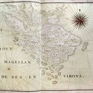
Jigsaw Puzzle : Map of Eastern North America: Florida to Chesapeake Bay (lithograph)
")
")


![]()
Jigsaw Puzzles from Fine Art Finder
Map of Eastern North America: Florida to Chesapeake Bay (lithograph)
XCF259782 Map of Eastern North America: Florida to Chesapeake Bay (lithograph) by White, John (fl.1570-93) (after); 37x47.2 cm; Private Collection; English, out of copyright
Media ID 12775614
© www.bridgemanart.com
Bermuda Crest Dolphin Flying Fish Navigation New England Sir Walter Raleigh Virginia Bahama Islands Squirrel Fish
Jigsaw Puzzle (500 Pieces)
Discover the beauty and history of Eastern North America with our captivating jigsaw puzzle from Media Storehouse. This intricately detailed puzzle features a stunning lithograph of a map by John White, depicting the region from Florida to the Chesapeake Bay. Originally created in the late 16th century, this rare and historically significant map is now available for puzzle enthusiasts to piece together in the comfort of their own home. Explore the intricacies of the Eastern seaboard, from the sun-soaked shores of Florida to the historic waters of the Chesapeake Bay. Immerse yourself in the rich history and natural wonders of this fascinating region with our high-quality, jigsaw puzzle.
500 piece puzzles are custom made in the UK and hand-finished on 100% recycled 1.5 mm millboard. There is a level of repetition in jigsaw shapes with each matching piece away from its pair. The completed puzzle measures 38x50cm and is delivered packaged in an attractive presentation box specially designed to fit most letter box slots
Jigsaw Puzzles are an ideal gift for any occasion
Estimated Product Size is 50.2cm x 38cm (19.8" x 15")
These are individually made so all sizes are approximate
Artwork printed orientated as per the preview above, with landscape (horizontal) or portrait (vertical) orientation to match the source image.
FEATURES IN THESE COLLECTIONS
> Fine Art Finder
> Artists
> John (after) White
> Fine Art Finder
> Maps (celestial & Terrestrial)
EDITORS COMMENTS
This lithograph, titled "Map of Eastern North America: Florida to Chesapeake Bay" takes us on a visual journey through the diverse landscapes and seascapes of this region. Created by John White in the late 16th century, this print showcases his remarkable talent for cartography. The map encompasses an extensive area, stretching from Florida to Chesapeake Bay, offering a comprehensive view of the eastern coast. It highlights various significant locations such as Norumbega, New England, Bermuda, and the Bahama Islands. The intricate details include crests representing Sir Walter Raleigh and navigational elements that hint at the exploration spirit of that era. As we explore further into this artwork's intricacies, our eyes are drawn to the beautifully depicted marine fauna. From dolphins gracefully swimming through waves to flying fish soaring above ships navigating these waters - every element comes alive with vividness and precision. The inclusion of squirrel fish adds an intriguing touch to this composition. These small but vibrant creatures symbolize nature's diversity along these coastal regions. This lithograph not only serves as a historical document but also captivates viewers with its artistic brilliance. Its sizeable dimensions allow for a closer examination of each detail meticulously etched onto paper. Displayed in private collections today, this work stands as a testament to John White's skillful craftsmanship and dedication to capturing both geographical accuracy and aesthetic beauty within one piece.
MADE IN THE UK
Safe Shipping with 30 Day Money Back Guarantee
FREE PERSONALISATION*
We are proud to offer a range of customisation features including Personalised Captions, Color Filters and Picture Zoom Tools
SECURE PAYMENTS
We happily accept a wide range of payment options so you can pay for the things you need in the way that is most convenient for you
* Options may vary by product and licensing agreement. Zoomed Pictures can be adjusted in the Basket.