Home > Animals > Mammals > Cats (Domestic) > Russian White
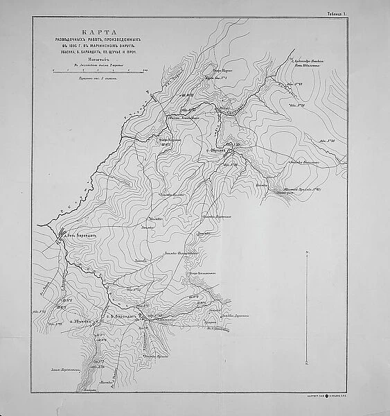
Map of exploration work carried out in 1895 in the Mariinsky District. Ubienka.. 1895. Creator: Unknown
![]()

Wall Art and Photo Gifts from Heritage Images
Map of exploration work carried out in 1895 in the Mariinsky District. Ubienka.. 1895. Creator: Unknown
Map of exploration work carried out in 1895 in the Mariinsky District. Ubienka, B. Barandat, lake; Pike and so on, 1895
Heritage Images features heritage image collections
Media ID 35130855
© Heritage Art/Heritage Images
Cartographic Cartography Map Making Mapmaking Russian Federation Russian State Library Siberia Russia Meeting Of Frontiers
FEATURES IN THESE COLLECTIONS
> Animals
> Mammals
> Cats (Domestic)
> Russian White
> Europe
> Russia
> Lakes
> Related Images
> Europe
> Russia
> Related Images
> Maps and Charts
> Early Maps
> Maps and Charts
> Related Images
> Popular Themes
> Lake District
EDITORS COMMENTS
This black and white map print dates back to 1895 and depicts the exploration work carried out in the Mariinsky District, specifically in the area of Ubienka, Russia. The map is a testament to the rich cartographic heritage of the late 19th century and showcases the meticulous detail and precision of mapmaking during this era. The map is adorned with various topographical features, including the B. Barandat Lake, Pike, and other geographical landmarks. The intricate lettering and labeling on the map reflect the rigorous scientific approach to mapping that was prevalent during this period. The map serves as an essential historical document, providing valuable insights into the geography of Siberia, Russia, during the late 1800s. The map's creation coincided with a time of significant exploration and expansion of the Russian Empire's frontiers. The map's intricate details and accurate representation of the terrain would have been invaluable to explorers, settlers, and government officials seeking to understand and navigate the vast and largely unexplored regions of Russia's far east. The map is a fascinating glimpse into the past, offering a unique perspective on the geography and history of Russia during the late 19th century. Its intricate details and historical significance make it an essential addition to any collection of historic maps or Russian heritage art.
MADE IN THE UK
Safe Shipping with 30 Day Money Back Guarantee
FREE PERSONALISATION*
We are proud to offer a range of customisation features including Personalised Captions, Color Filters and Picture Zoom Tools
SECURE PAYMENTS
We happily accept a wide range of payment options so you can pay for the things you need in the way that is most convenient for you
* Options may vary by product and licensing agreement. Zoomed Pictures can be adjusted in the Basket.

