Home > Europe > Russia > Maps
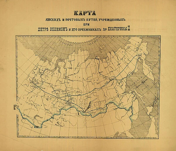
[Karty pochtovykh soobshcheni¯i? uchrezhdennykh v Rossi¯i?skoi? Imperi¯i pri T?S?ari?e... (186-?). Creator: Unknown
![]()

Wall Art and Photo Gifts from Heritage Images
[Karty pochtovykh soobshcheni¯i? uchrezhdennykh v Rossi¯i?skoi? Imperi¯i pri T?S?ari?e... (186-?). Creator: Unknown
[Karty pochtovykh soobshcheni¯i? uchrezhdennykh v Rossi¯i?skoi? Imperi¯i pri T?S?ari?e? Aleksi?e?i?e? Mikhailovichi?e? i ego preemnikakh do Ekateriny II], (186-?). Shows designated national postal routes established in various imperial reigns
Heritage Images features heritage image collections
Media ID 35130497
© Heritage Art/Heritage Images
1860s Cartographic Cartography Communication Cyrillic Map Making Mapmaking Russian Federation Meeting Of Frontiers Postal Service
FEATURES IN THESE COLLECTIONS
> Europe
> Russia
> Related Images
> Maps and Charts
> Early Maps
> Maps and Charts
> Related Images
EDITORS COMMENTS
This 19th century map print, titled "[Karty pochtovykh soobshcheniya uchrezhdennykh v Rossiyskoi Imperii pri Tsarakh Aleksandre I Mikhailoviche i ego preemnikakh do Ekateriny II]" (Postal Maps of the Established Postal Services in the Russian Empire under the Reigns of Alexander I Mikhailovich and his Successors up to Catherine II), showcases the designated national postal routes established during various imperial reigns in Russia. The map, created in the 1860s, is a testament to the evolution of communication and transportation networks in the Russian Empire. The map is rich in intricate detail, with vibrant colors and bold Cyrillic text that adds to its historic allure. The location of each postal route is marked with precise accuracy, reflecting the meticulous efforts of the cartographers and mapmakers of the time. The meeting of frontiers and the diverse geographical features of the Russian Federation are depicted with remarkable clarity. This map is an essential addition to any collection of historic cartography or Russian heritage art. Its intriguing concept and historical significance make it a valuable resource for scholars, historians, and enthusiasts of geography and communication history. The Library of Congress is fortunate to have this rare and beautiful map in its collection, preserving it for future generations to study and appreciate.
MADE IN THE UK
Safe Shipping with 30 Day Money Back Guarantee
FREE PERSONALISATION*
We are proud to offer a range of customisation features including Personalised Captions, Color Filters and Picture Zoom Tools
SECURE PAYMENTS
We happily accept a wide range of payment options so you can pay for the things you need in the way that is most convenient for you
* Options may vary by product and licensing agreement. Zoomed Pictures can be adjusted in the Basket.


