Home > Animals > Mammals > Muridae > Desert Mouse
'Afrique Du Nord-Est; Le Nord-Est Africain, 1914. Creator: Unknown

![]()
Wall Art and Photo Gifts from Heritage Images
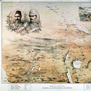
'Afrique Du Nord-Est; Le Nord-Est Africain, 1914. Creator: Unknown
'Afrique Du Nord-Est; Le Nord-Est Africain, 1914.. From "Grande Geographie Bong Illustree", 1914
Heritage Images features heritage image collections
Media ID 36295895
© The Print Collector/Heritage Images
Cartography Desert Libya Map Making Mapmaking Mediterranean Sea North Africa North African Red Sea Sahara Sahara Desert Africa Sudan
FEATURES IN THESE COLLECTIONS
> Africa
> Egypt
> Related Images
> Africa
> Libya
> Related Images
> Africa
> Sudan
> Related Images
> Animals
> Mammals
> Muridae
> Desert Mouse
EDITORS COMMENTS
This map print, titled 'Afrique Du Nord-Est; Le Nord-Est Africain' (Northeastern Africa, 1914), is an intriguing glimpse into the geographical understanding of the world during the early 20th century. The creator of this map remains unknown, but it was published in the esteemed European geographical journal 'Grande Geographie Bong Illustree' in 1914. The map showcases the northeastern region of Africa, including Egypt, Libya, Sudan, Mizraim, and the coastal areas along the Mediterranean Sea, Red Sea, and the Gulf of Suez. The Sahara Desert, a vast expanse of arid terrain, dominates the central and southern parts of the map. The map's intricate details reveal the cartographer's meticulous approach to mapmaking. The coastlines are delicately rendered, with bays, inlets, and islands accurately depicted. The various borders of countries are clearly defined, and the locations of major cities and geographical features are marked with labels. The map's color palette, predominantly earthy tones, adds to its authenticity and historical charm. The use of brown for the Sahara Desert, green for the Mediterranean Sea, and beige for the sandy regions effectively highlights the diverse landscapes of the African continent. This map offers a fascinating insight into the geographical knowledge of the early 1900s, a time when exploration and discovery were shaping the world's understanding of its own geography. The intricacies of the mapmaking process are beautifully captured in this print, making it a valuable addition to any collection of historical cartography.
MADE IN THE UK
Safe Shipping with 30 Day Money Back Guarantee
FREE PERSONALISATION*
We are proud to offer a range of customisation features including Personalised Captions, Color Filters and Picture Zoom Tools
SECURE PAYMENTS
We happily accept a wide range of payment options so you can pay for the things you need in the way that is most convenient for you
* Options may vary by product and licensing agreement. Zoomed Pictures can be adjusted in the Basket.