Greetings Card > Europe > United Kingdom > Scotland > Western Isles > Related Images
Greetings Card : Old Map of the Western Isles from the Philips Handy Atlas of 1882


![]()
Cards from MapSeeker
Old Map of the Western Isles from the Philips Handy Atlas of 1882
PHA031
Welcome to the Mapseeker Image library and enter an historic gateway to one of the largest on-line collections of Historic Maps, Nostalgic Views, Vista's and Panorama's from a World gone by.
Media ID 20348181
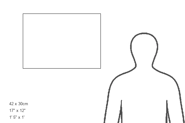
Greetings Card Large (A4)
Step back in time with our exquisite selection of Old Map Greeting Cards from Media Storehouse. This particular design features an enchanting Old Map of the Western Isles, taken from the Philips Handy Atlas of 1882, published by MapSeeker. Each card is meticulously printed on high-quality paper, capturing the intricate details and antique charm of the map. Send a piece of history with these unique and thoughtful cards for any occasion. Perfect for those who appreciate the beauty of the past and the joy of sending a personal message. Add a touch of nostalgia to your correspondence with Media Storehouse Old Map Greeting Cards.
Create your own large greetings card. Size when folded is A4 (21x30cm or 8.3x11.7 inches)
Greetings Cards suitable for Birthdays, Weddings, Anniversaries, Graduations, Thank You and much more
Estimated Image Size (if not cropped) is 21cm x 29.7cm (8.3" x 11.7")
Estimated Product Size is 42cm x 29.7cm (16.5" x 11.7")
These are individually made so all sizes are approximate
Artwork printed orientated as per the preview above, with portrait (vertical) orientation to match the source image.
FEATURES IN THESE COLLECTIONS
> Europe
> United Kingdom
> Scotland
> Western Isles
> Related Images
> MapSeeker
> Maps from the British Isles
> Scotland and Counties PORTFOLIO
EDITORS COMMENTS
This print showcases an exquisite piece of cartographic history, the "Old Map of the Western Isles from the Philips Handy Atlas of 1882". Steeped in nostalgia and intricate details, this vintage map takes us on a journey back to a bygone era. The Western Isles, also known as the Outer Hebrides, are beautifully depicted with remarkable precision and artistry. Every contour line and coastal feature is meticulously etched onto this time-worn parchment. The delicate shading brings to life the rugged landscapes, while tiny symbols denote towns, villages, and landmarks scattered across these remote Scottish islands. As we gaze upon this ancient treasure trove of geographical knowledge, it transports us to a world where exploration was still unfolding. It evokes images of intrepid sailors navigating treacherous waters in search of new lands or merchants plotting their trade routes amidst turbulent seas. Beyond its historical significance lies an aesthetic appeal that captivates our senses. The sepia tones lend an air of antiquity to this mesmerizing artwork; each crease and faded ink stroke tells a tale untold. This photograph preserves not only the map itself but also the essence of adventure encapsulated within its borders. Whether you are an avid collector or simply appreciate glimpses into our past, this print offers a window into forgotten times—a tangible connection between generations separated by centuries yet united through curiosity and discovery.
MADE IN THE UK
Safe Shipping with 30 Day Money Back Guarantee
FREE PERSONALISATION*
We are proud to offer a range of customisation features including Personalised Captions, Color Filters and Picture Zoom Tools
SECURE PAYMENTS
We happily accept a wide range of payment options so you can pay for the things you need in the way that is most convenient for you
* Options may vary by product and licensing agreement. Zoomed Pictures can be adjusted in the Basket.