Greetings Card > Europe > United Kingdom > England > Lancaster
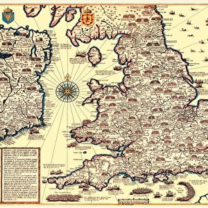
Greetings Card : Map of England and Wales as it appeared under the House of Lancaster


![]()
Cards from MapSeeker
Map of England and Wales as it appeared under the House of Lancaster
BHISM005
Welcome to the Mapseeker Image library and enter an historic gateway to one of the largest on-line collections of Historic Maps, Nostalgic Views, Vista's and Panorama's from a World gone by.
Media ID 20348262
Greetings Card Large (A4)
Discover the rich history of England and Wales with our unique Greetings Cards from Media Storehouse. Featuring an intricately detailed Map of England and Wales as it appeared under the House of Lancaster, sourced from MapSeeker. These cards are more than just a greeting, they're a journey back in time. Perfect for history enthusiasts, or as a thoughtful and distinctive gift for any occasion. Send a piece of the past with our Map of England and Wales Greetings Cards (BHISM005).
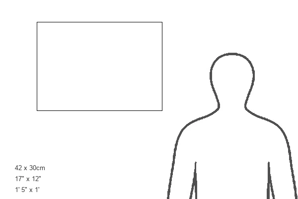
Create your own large greetings card. Size when folded is A4 (21x30cm or 8.3x11.7 inches)
Greetings Cards suitable for Birthdays, Weddings, Anniversaries, Graduations, Thank You and much more
Estimated Image Size (if not cropped) is 21cm x 29.7cm (8.3" x 11.7")
Estimated Product Size is 42cm x 29.7cm (16.5" x 11.7")
These are individually made so all sizes are approximate
Artwork printed orientated as per the preview above, with portrait (vertical) orientation to match the source image.
FEATURES IN THESE COLLECTIONS
> Europe
> United Kingdom
> England
> Lancaster
> Europe
> United Kingdom
> England
> Maps
> Europe
> United Kingdom
> Wales
> Maps
> Europe
> United Kingdom
> Wales
> Posters
> Europe
> United Kingdom
> Wales
> Related Images
> Maps and Charts
> Related Images
> Maps and Charts
> Wales
> MapSeeker
> Maps from the British Isles
> England with Wales PORTFOLIO
EDITORS COMMENTS
This print showcases a historical treasure, the "Map of England and Wales as it appeared under the House of Lancaster (BHISM005)". A visual portal into the past, this map offers a fascinating glimpse into medieval times when the House of Lancaster held sway over these lands. The intricate details on this print bring to life an era filled with political intrigue and power struggles. The careful cartographic craftsmanship highlights various cities, towns, rivers, and landmarks that were significant during the reign of the Lancastrian dynasty. From bustling London to picturesque York, each location is meticulously depicted with precision. As we gaze upon this map, we are transported back in time to an age where knights roamed these lands and castles dotted the countryside. It serves as a reminder of how history has shaped our present-day landscape. Beyond its aesthetic appeal, this print holds immense educational value for historians and enthusiasts alike. It invites us to explore England and Wales through a different lens - one that reveals not only geographical boundaries but also sheds light on dynastic rule. Whether displayed in homes or academic institutions, this remarkable MapSeeker print sparks curiosity about our shared heritage while honoring an important period in British history: the reign of the House of Lancaster.
MADE IN THE UK
Safe Shipping with 30 Day Money Back Guarantee
FREE PERSONALISATION*
We are proud to offer a range of customisation features including Personalised Captions, Color Filters and Picture Zoom Tools
SECURE PAYMENTS
We happily accept a wide range of payment options so you can pay for the things you need in the way that is most convenient for you
* Options may vary by product and licensing agreement. Zoomed Pictures can be adjusted in the Basket.