Greetings Card > Europe > United Kingdom > England > London > Royalty
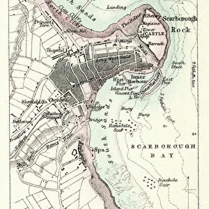
Greetings Card : Old Map of Scarborough 1898 from the Royal Atlas by Bartholomew


![]()
Cards from MapSeeker
Old Map of Scarborough 1898 from the Royal Atlas by Bartholomew
A fine very detailed plan of the Seaside Town of Scarborough from 1898 remastered from an original contained within " The Royal Atlas of England and Wales" ; edited by J.G. Bartholomew, published by George Newnes, Limited, London
Welcome to the Mapseeker Image library and enter an historic gateway to one of the largest on-line collections of Historic Maps, Nostalgic Views, Vista's and Panorama's from a World gone by.
Media ID 20347789
Bartholomew Bartholomew Map Historic Map Old Town Plan Royal Atlas Royal Atlas Map Scarborough
Greetings Card (A5)
Step back in time with our exquisite Old Map of Scarborough 1898 Greetings Cards from Media Storehouse. Meticulously remastered from the original map contained within "The Royal Atlas of England and Wales," these cards feature a finely detailed plan of the historic seaside town of Scarborough as it appeared over a century ago. The Old Map of Scarborough 1898 Greetings Cards are a thoughtful and unique way to send a message, perfect for birthdays, anniversaries, or just to brighten someone's day. Each card is a piece of history, showcasing the charm and character of Scarborough in a bygone era. Send a piece of the past with our Old Map of Scarborough 1898 Greetings Cards.
Create your own greetings card. Size when folded is A5 (14.5x21cm or 5.7x8.3 inches)
Greetings Cards suitable for Birthdays, Weddings, Anniversaries, Graduations, Thank You and much more
Estimated Image Size (if not cropped) is 14.5cm x 21cm (5.7" x 8.3")
Estimated Product Size is 29cm x 21cm (11.4" x 8.3")
These are individually made so all sizes are approximate
Artwork printed orientated as per the preview above, with portrait (vertical) orientation to match the source image.
FEATURES IN THESE COLLECTIONS
> Arts
> Photorealistic artworks
> Detailed art pieces
> Masterful detailing in art
> Europe
> United Kingdom
> England
> London
> Royalty
> Europe
> United Kingdom
> England
> Maps
> Europe
> United Kingdom
> Wales
> Maps
> Europe
> United Kingdom
> Wales
> Posters
> Maps and Charts
> Related Images
> Maps and Charts
> Wales
> MapSeeker
> British Town And City Plans
> English & Welsh PORTFOLIO
EDITORS COMMENTS
This beautifully remastered print showcases the Old Map of Scarborough from 1898, taken from the esteemed Royal Atlas by Bartholomew. Offering a glimpse into the past, this fine and highly detailed plan reveals the charming seaside town of Scarborough as it existed over a century ago. Contained within "The Royal Atlas of England and Wales" edited by J. G. Bartholomew and published by George Newnes, Limited in London, this historic map holds immense historical significance. It captures the essence of Scarborough's rich heritage and provides a fascinating insight into its development throughout time. With intricate details meticulously preserved during remastering, this old town plan allows us to explore every nook and cranny of Scarborough as it once was. From its bustling streets to its iconic landmarks, one can trace the footsteps of generations long gone. Whether you are an avid historian or simply captivated by vintage maps, this print is sure to transport you back in time. Immerse yourself in Scarborough's past glory as you admire this remarkable piece that has stood the test of time
MADE IN THE UK
Safe Shipping with 30 Day Money Back Guarantee
FREE PERSONALISATION*
We are proud to offer a range of customisation features including Personalised Captions, Color Filters and Picture Zoom Tools
SECURE PAYMENTS
We happily accept a wide range of payment options so you can pay for the things you need in the way that is most convenient for you
* Options may vary by product and licensing agreement. Zoomed Pictures can be adjusted in the Basket.