Greetings Card > Europe > France > Paris > Maps
Greetings Card : Map of Khartoum and Vicinity, c1885


![]()
Cards from Heritage Images
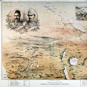
Map of Khartoum and Vicinity, c1885
Map of Khartoum and Vicinity, c1885. Episode of the Mahdist War, (1881-1899). From British Battles on Land and Sea, Vol. IV, by James Grant. [Cassell Petter & Galpin, London, Paris & Melbourne, c1880]
Heritage Images features heritage image collections
Media ID 14992049
© The Print Collector
British Battles On Land And Sea Cassell Petter Galpin Grant Imperialism James Grant Khartoum Mahdist War Petter Galpin Sudan Sudan Campaign Cassell
Greetings Card Large (A4)
Step back in time with our unique and captivating selection of greeting cards from Media Storehouse. This particular card features an intriguing map of Khartoum and its vicinity from 1885, taken from the British Battles on Land and Sea, Vol. IV by James Grant. The map offers a fascinating glimpse into the historical context of the Mahdist War (1881-1899), showcasing the strategic layout of the region during a pivotal moment in history. Perfect for history enthusiasts, geography aficionados, or anyone looking to add a touch of the past to their correspondence, this vintage map card is sure to make a memorable impression.
Create your own large greetings card. Size when folded is A4 (21x30cm or 8.3x11.7 inches)
Greetings Cards suitable for Birthdays, Weddings, Anniversaries, Graduations, Thank You and much more
Estimated Image Size (if not cropped) is 21cm x 29.7cm (8.3" x 11.7")
Estimated Product Size is 42cm x 29.7cm (16.5" x 11.7")
These are individually made so all sizes are approximate
Artwork printed orientated as per the preview above, with portrait (vertical) orientation to match the source image.
FEATURES IN THESE COLLECTIONS
> Africa
> Sudan
> Related Images
> Arts
> Literature
> Europe
> France
> Canton
> Landes
> Europe
> France
> Paris
> Maps
> Historic
> Battles
> Related Images
> Maps and Charts
> Related Images
EDITORS COMMENTS
This print showcases a historical map of Khartoum and its surrounding areas, dating back to approximately 1885. The image is derived from James Grant's renowned book "British Battles on Land and Sea" which provides an insightful account of the Mahdist War that occurred between 1881 and 1899 in Sudan. The map itself serves as a testament to Britain's colonial presence during the late 19th century, highlighting the imperialistic ambitions that characterized this era. It offers a glimpse into the geographical layout of Khartoum, presenting viewers with a visual representation of the city's streets, landmarks, and strategic locations. As we delve into this monochrome masterpiece, one cannot help but appreciate both its artistic value and historical significance. The intricate details meticulously etched onto paper transport us back in time, allowing us to immerse ourselves in an epoch defined by conflict and exploration. Through this print, we are reminded of how literature can serve as a powerful tool for preserving our collective memory. Grant's work not only educates readers about significant events like the Mahdist War but also sheds light on Britain's involvement in shaping global history. This remarkable piece from "The Print Collector" collection encapsulates an important chapter in human civilization – one marked by ambition, conquests, and cultural exchange. It invites us to reflect upon our past while contemplating the impact it continues to have on our present-day world.
MADE IN THE UK
Safe Shipping with 30 Day Money Back Guarantee
FREE PERSONALISATION*
We are proud to offer a range of customisation features including Personalised Captions, Color Filters and Picture Zoom Tools
SECURE PAYMENTS
We happily accept a wide range of payment options so you can pay for the things you need in the way that is most convenient for you
* Options may vary by product and licensing agreement. Zoomed Pictures can be adjusted in the Basket.