Greetings Card > Europe > Norway > Maps
Greetings Card : Topographic maps European glaciers, lithograph, published in 1897


![]()
Cards from Fine Art Storehouse
Topographic maps European glaciers, lithograph, published in 1897
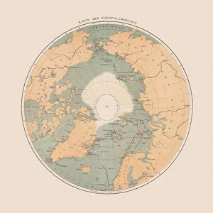
Topographic maps European glaciers at the end of the 19th century: 1) Aletsch Glacier (Switzerland); 2) Rhone Glacier (Switzerland); 3) Pasterze Glacier (Austria); 4) Jostedal Glacier (Jostedalsbreen, Norway). Lithograph, published in 1897
Unleash your creativity and transform your space into a visual masterpiece!
ZU_09
Media ID 18292345
Greetings Card Large (A4)
Step back in time with our exquisite range of antique greeting cards from Media Storehouse. Featuring stunning lithographs published in 1897 by ZU_09 from the Fine Art Storehouse, these cards showcase the breathtaking beauty of Europe's topographic maps of glaciers. Marvel at the intricate details of the Aletsch Glacier in Switzerland, the Rhone Glacier in Switzerland, the Pasterze Glacier in Austria. These unique, vintage-inspired cards are the perfect way to add a touch of history and elegance to your correspondence. Ideal for special occasions or just to brighten someone's day, these cards are a must-have for collectors and map enthusiasts alike.
Create your own large greetings card. Size when folded is A4 (21x30cm or 8.3x11.7 inches)
Greetings Cards suitable for Birthdays, Weddings, Anniversaries, Graduations, Thank You and much more
Estimated Image Size (if not cropped) is 21cm x 29.7cm (8.3" x 11.7")
Estimated Product Size is 42cm x 29.7cm (16.5" x 11.7")
These are individually made so all sizes are approximate
Artwork printed orientated as per the preview above, with portrait (vertical) orientation to match the source image.
FEATURES IN THESE COLLECTIONS
> Fine Art Storehouse
> Map
> Historical Maps
> Europe
> Austria
> Related Images
> Europe
> Norway
> Related Images
> Europe
> Related Images
> Europe
> Switzerland
> Maps
> Europe
> Switzerland
> Posters
> Europe
> Switzerland
> Related Images
EDITORS COMMENTS
This lithograph, published in 1897, showcases the topographic maps of European glaciers at the end of the 19th century. The print features four prominent glaciers: Aletsch Glacier in Switzerland, Rhone Glacier also in Switzerland, Pasterze Glacier in Austria, and Jostedal Glacier (Jostedalsbreen) located in Norway. The intricate details captured by ZU_09 transport us back to a time when these majestic icy formations were still largely unexplored. Each glacier is meticulously depicted with contour lines that highlight their unique shapes and elevations. The Aletsch Glacier stands out with its vast expanse and impressive ice flow, while the Rhone Glacier displays its grandeur through deep crevasses and rugged terrain. As we study this historical artwork, it becomes evident that these glaciers played a significant role not only as natural wonders but also as vital sources of freshwater for surrounding regions. This lithograph serves as a testament to human curiosity about our planet's ever-changing landscapes. Through this print, we are reminded of the importance of preserving these fragile ecosystems for future generations. It invites us to reflect on how climate change has impacted these glaciers over time and underscores the urgency to protect them from further degradation. ZU_09's meticulous attention to detail brings forth an appreciation for both artistry and scientific accuracy within this stunning piece.
MADE IN THE UK
Safe Shipping with 30 Day Money Back Guarantee
FREE PERSONALISATION*
We are proud to offer a range of customisation features including Personalised Captions, Color Filters and Picture Zoom Tools
SECURE PAYMENTS
We happily accept a wide range of payment options so you can pay for the things you need in the way that is most convenient for you
* Options may vary by product and licensing agreement. Zoomed Pictures can be adjusted in the Basket.