Greetings Card > Fine Art Storehouse > Map
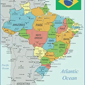
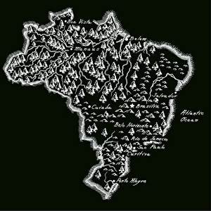
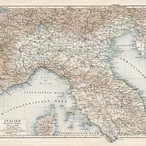
Greetings Card : Map of Brazil. Lithograph, lithograph, published in 1874


![]()
Cards from Fine Art Storehouse
Map of Brazil. Lithograph, lithograph, published in 1874
Antique map of Brazil. Lithograph, published in 1874
Unleash your creativity and transform your space into a visual masterpiece!
Media ID 13666719
© ZU_09
78279 American Culture Antiquities Atlantic Ocean Brazil Brazilian Culture Country Geographic Area Image Date Land South America The Americas Topography Image Created 19th Century
Greetings Card Large (A4)
Step back in time with our exquisite antique Map of Brazil Greetings Cards from Media Storehouse's Fine Art Storehouse collection. These beautifully preserved lithographs, published in 1874, make for unique and thoughtful gifts. Each card features intricate details and vibrant colors, transporting the recipient on a journey through history. Perfect for birthdays, anniversaries, or just to brighten someone's day, these cards are a celebration of the rich history and culture of Brazil. Add a touch of nostalgia and elegance to your greetings with Media Storehouse's Antique Map of Brazil Greetings Cards.
Create your own large greetings card. Size when folded is A4 (21x30cm or 8.3x11.7 inches)
Greetings Cards suitable for Birthdays, Weddings, Anniversaries, Graduations, Thank You and much more
Estimated Image Size (if not cropped) is 21cm x 29.7cm (8.3" x 11.7")
Estimated Product Size is 42cm x 29.7cm (16.5" x 11.7")
These are individually made so all sizes are approximate
Artwork printed orientated as per the preview above, with portrait (vertical) orientation to match the source image.
FEATURES IN THESE COLLECTIONS
> Fine Art Storehouse
> Map
> Historical Maps
EDITORS COMMENTS
This lithograph, dating back to 1874, showcases the rich history and cultural heritage of Brazil. The antique map of Brazil offers a glimpse into the country's past, with intricate details meticulously engraved on its surface. As we gaze upon this vertical image, we are transported to a time when cartography was an art form in itself. The topography of Brazil is beautifully depicted, revealing the diverse landscapes that span across this vast South American nation. From the dense Amazon rainforest in the north to the sprawling plains and rolling hills in central regions, every contour is carefully etched onto this lithograph. As our eyes wander further south on this historic map, we encounter Brazil's extensive coastline along the Atlantic Ocean. This visual representation not only highlights its geographic boundaries but also emphasizes its connection to neighboring countries within "the Americas". Beyond its geographical significance lies a deeper appreciation for Brazilian culture and ancient history. The lithograph serves as a testament to how these elements have shaped and influenced society over centuries. Preserved through time, this photograph captures both the essence of 19th-century photography techniques and the allure of antiquities. It stands as a remarkable piece that allows us to marvel at Brazil's natural beauty while reflecting on its historical roots.
MADE IN THE UK
Safe Shipping with 30 Day Money Back Guarantee
FREE PERSONALISATION*
We are proud to offer a range of customisation features including Personalised Captions, Color Filters and Picture Zoom Tools
SECURE PAYMENTS
We happily accept a wide range of payment options so you can pay for the things you need in the way that is most convenient for you
* Options may vary by product and licensing agreement. Zoomed Pictures can be adjusted in the Basket.