Greetings Card > Arts > Artists > C > Craig Craig
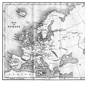
Greetings Card : Victorian Map of Europe


![]()
Cards from Fine Art Storehouse
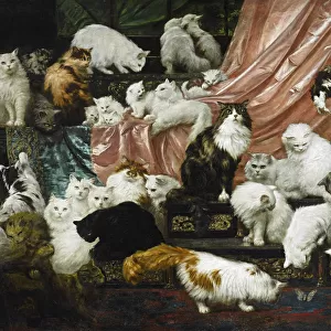
Victorian Map of Europe
Engraved illustrations of Europe in the Time of Charlemagne from Iconographic Encyclopedia of Science, Literature and Art, Published in 1851. Copyright has expired on this artwork. Digitally restored
Unleash your creativity and transform your space into a visual masterpiece!
bauhaus1000
Media ID 13666975
© Craig McCausland
1850 1859 Austria Belgian Culture Belgium British Culture Chart Country Geographic Area Denmark Diagram Drypoint European Culture French Culture German Culture Greece Greek Culture Image Created 1850 1859 Irish Culture Italian Culture Netherlands Northern Ireland Norway Plan Poland Republic Of Ireland Steel Engraving Sweden Swiss Culture Switzerland World Map Drawing Art Product Image Created 19th Century Victorian Style
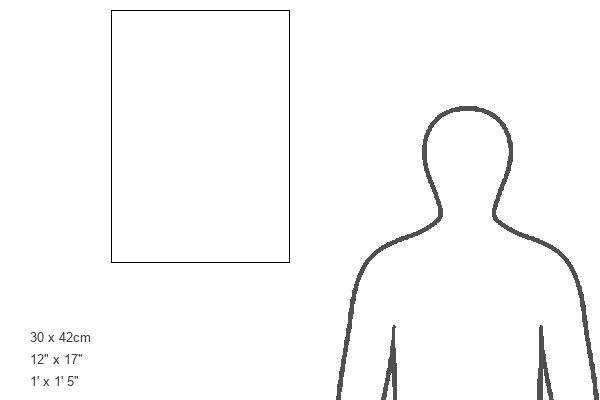
Greetings Card Large (A4)
Step back in time with our exquisite selection of Victorian-inspired greeting cards from Media Storehouse. Featuring a stunning, digitally restored engraving of Europe from the Iconographic Encyclopedia of Science, Literature and Art, published in 1851, these cards transport you to an era of grandeur and historical significance. The intricate details of the map, showcasing Europe during the time of Charlemagne, are brought to life through the masterful artistry of bauhaus1000 from our Fine Art Storehouse. Perfect for history enthusiasts or those seeking a touch of elegance in their correspondence, these vintage greeting cards are a unique and thoughtful addition to any occasion.
Create your own large greetings card. Size when folded is A4 (21x30cm or 8.3x11.7 inches)
Greetings Cards suitable for Birthdays, Weddings, Anniversaries, Graduations, Thank You and much more
Estimated Image Size (if not cropped) is 29.7cm x 21cm (11.7" x 8.3")
Estimated Product Size is 29.7cm x 42cm (11.7" x 16.5")
These are individually made so all sizes are approximate
Artwork printed orientated as per the preview above, with landscape (horizontal) orientation to match the source image.
FEATURES IN THESE COLLECTIONS
> Fine Art Storehouse
> Map
> Denmark Maps
> Fine Art Storehouse
> Map
> Historical Maps
> Fine Art Storehouse
> Map
> Italian Maps
> Arts
> Artists
> C
> Craig Craig
> Arts
> Literature
> Illustration
> Arts
> Literature
> Arts
> Street art graffiti
> Digital art
> Digital paintings
> Europe
> Austria
> Paintings
> Europe
> Austria
> Related Images
> Europe
> Belgium
> Paintings
EDITORS COMMENTS
This print showcases a meticulously engraved Victorian Map of Europe, offering a fascinating glimpse into the continent during the time of Charlemagne. Published in 1851 as part of the Iconographic Encyclopedia of Science, Literature and Art, this artwork has now entered the public domain after its copyright expired. Painstakingly restored digitally, it retains its original charm and intricate details. The map transports us back to the 19th century with its distinct style, reminiscent of woodcut illustrations and paintings from that era. It serves as both a historical document and an artistic masterpiece, capturing European culture at a pivotal moment in history. From Poland to Spain, Italy to Greece, Switzerland to Germany – each country is depicted with precision and care. The engraving beautifully portrays famous landmarks and physical geography across Europe's diverse landscape. As we explore this enchanting image created over 150 years ago using drypoint engraving techniques on steel plates, we are reminded of how travel and tourism have evolved throughout time. This map not only offers geographical insights but also provides glimpses into Victorian society's fascination with exploration. Immerse yourself in this remarkable piece that seamlessly combines artistry with cartography. Let your imagination wander through centuries past as you appreciate the craftsmanship behind this stunning representation of European history.
MADE IN THE UK
Safe Shipping with 30 Day Money Back Guarantee
FREE PERSONALISATION*
We are proud to offer a range of customisation features including Personalised Captions, Color Filters and Picture Zoom Tools
SECURE PAYMENTS
We happily accept a wide range of payment options so you can pay for the things you need in the way that is most convenient for you
* Options may vary by product and licensing agreement. Zoomed Pictures can be adjusted in the Basket.